Adare geodata
Adare (Queensland) is a section of populated place; located in Australia in Australia/Brisbane (GMT+10) time zone. With population of 861 people, there are 4040 cities with bigger population in this country. Compared to other cities in Australia, 81.7% of cities are located further ↓South; 83.5% of cities are located further ←West and 77.9% of cities have lower elevation than Adare. Note1


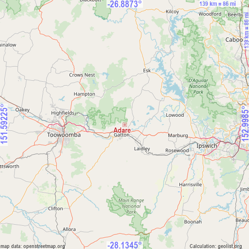
Adare GPS coordinates[2]
27° 30' 45.612" South, 152° 17' 43.332" East
| Map corner | latitude | longitude |
|---|---|---|
| Upper-left | -26.8873°, | 151.59225° |
| Center: | -27.51267°, | 152.29537° |
| Lower-right: | -28.1345°, | 152.9985° |
| Map W x H: | 138.7×138.7 km | = 86.2×86.2mi |
| max Lat: | -10.58257° ⇑18.3% North |
| Adare: | -27.51267° |
| min Lat: | ⇓81.7% South -43.31423° |
| min Long | Adare | max Long |
| 113.53327° | 152.29537° | 153.61246° |
| W 83.5%⇐ | ⇒16.5% E |
Elevation
Elevation of Adare is 155 m = 509 ft, and this is 33 m = 108 ft above average elevation for this country.
| Max E: |
1715 m = 5627 ft | 22.1% |
| Adare | 155 m 509 ft | |
| Avg. | 122 m = 400 ft | |
Min E: |
-2 m = -7 ft | 77.9% |
See also: Australia elevation on elevation.city.
Geographical zone
Adare is located in South temperate zone (between Tropic of Capricorn and the Antarctic Circle). Distance of this Southern Tropic circle is 453.2 km =281.6 mi to North.| Distance of | km | miles | from Adare |
|---|---|---|---|
| Equator | 3059.1 | 1900.8 | to North |
| Tropic Capricorn | 453.2 | 281.6 | to North |
| Antarctic Circle | 4342.1 | 2698.1 | to South |
| South Pole | 6947.9 | 4317.2 | to South |


Nearby cities:
15 places around Adare: (largest is in red/bold)
• Brightview
18.6 km =11.6 mi,  85°
85°
• Forest Hill
10.7 km =6.6 mi,  146°
146°
• Gatton
5.5 km =3.4 mi,  200°
200°
• Glenore Grove
10.6 km =6.6 mi,  102°
102°
• Grantham
11.8 km =7.3 mi,  231°
231°
• Hatton Vale
17.9 km =11.1 mi,  109°
109°
• Helidon
17.5 km =10.9 mi,  255°
255°
• Kensington Grove
17.6 km =10.9 mi, 97°
• Laidley
16.5 km =10.3 mi,  144°
144°
• Lockrose
16.4 km =10.2 mi,  80°
80°
• Lockyer Waters
12.7 km =7.9 mi,  59°
59°
• Placid Hills
8.2 km =5.1 mi, 228°
• Plainland
13.4 km =8.3 mi,  116°
116°
• Regency Downs
14.5 km =9 mi, 99°
• Spring Creek
7.5 km =4.7 mi,  28°
28°
Sources, notices
• [Note1] Compared only with cities in Australia existing in our database
• [Src1] Map data: © OpenStreetMap contributors (CC-BY-SA)
• [Src2] Other city data from geonames.org with taken over terms of usage.
• [Src3] Geographical zone / Annual Mean Temperature by Robert A. Rohde @ Wikipedia
