Forest Hill geodata
Forest Hill (Queensland) is a populated place; located in Australia in Australia/Brisbane (GMT+10) time zone. With population of 997 people, there are 3823 cities with bigger population in this country. Compared to other cities in Australia, 79.8% of cities are located further ↓South; 83.8% of cities are located further ←West and 68.7% of cities have lower elevation than Forest Hill. Note1


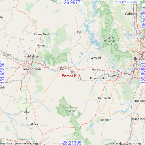
Forest Hill GPS coordinates[2]
27° 35' 33.432" South, 152° 21' 20.448" East
| Map corner | latitude | longitude |
|---|---|---|
| Upper-left | -26.9677°, | 151.65256° |
| Center: | -27.59262°, | 152.35568° |
| Lower-right: | -28.21399°, | 153.05881° |
| Map W x H: | 138.6×138.6 km | = 86.1×86.1mi |
| max Lat: | -10.58257° ⇑20.2% North |
| Forest Hill: | -27.59262° |
| min Lat: | ⇓79.8% South -43.31423° |
| min Long | Forest Hill | max Long |
| 113.53327° | 152.35568° | 153.61246° |
| W 83.8%⇐ | ⇒16.2% E |
Elevation
Elevation of Forest Hill is 95 m = 312 ft, and this is 27 m = 89 ft below average elevation for this country.
| Max E: |
1715 m = 5627 ft | 31.3% |
| Avg. | 122 m = 400 ft | |
| Forest Hill | 95 m = 312 ft | |
Min E: |
-2 m = -7 ft | 68.7% |
See also: Australia elevation on elevation.city.
Geographical zone
Forest Hill is located in South temperate zone (between Tropic of Capricorn and the Antarctic Circle). Distance of this Southern Tropic circle is 462.1 km =287.1 mi to North.| Distance of | km | miles | from Forest Hill |
|---|---|---|---|
| Equator | 3068 | 1906.4 | to North |
| Tropic Capricorn | 462.1 | 287.1 | to North |
| Antarctic Circle | 4333.2 | 2692.5 | to South |
| South Pole | 6939.1 | 4311.8 | to South |


Nearby cities:
15 places around Forest Hill: (largest is in red/bold)
• Adare
10.7 km =6.6 mi,  326°
326°
• Brightview
16.3 km =10.1 mi,  50°
50°
• Gatton
8.7 km =5.4 mi,  295°
295°
• Glenore Grove
7.9 km =4.9 mi,  33°
33°
• Grantham
15.3 km =9.5 mi,  275°
275°
• Hatton Vale
11.3 km =7 mi,  75°
75°
• Kensington Grove
13.3 km =8.3 mi,  59°
59°
• Laidley
5.8 km =3.6 mi,  140°
140°
• Lockrose
15.4 km =9.6 mi,  41°
41°
• Lockyer Waters
16.2 km =10.1 mi,  17°
17°
• Placid Hills
12.6 km =7.8 mi,  286°
286°
• Plainland
6.7 km =4.2 mi, 64°
• Regency Downs
10.6 km =6.6 mi, 51°
• Spring Creek
15.7 km =9.8 mi,  351°
351°
• Summerholm
9.7 km =6 mi,  106°
106°
Sources, notices
• [Note1] Compared only with cities in Australia existing in our database
• [Src1] Map data: © OpenStreetMap contributors (CC-BY-SA)
• [Src2] Other city data from geonames.org with taken over terms of usage.
• [Src3] Geographical zone / Annual Mean Temperature by Robert A. Rohde @ Wikipedia
