Gordonvale geodata
Gordonvale (Queensland) is a section of populated place; located in Australia in Australia/Brisbane (GMT+10) time zone. With population of 6,754 people, there are 1017 cities with bigger population in this country. Compared to other cities in Australia, 96.9% of cities are located further ↓South; 57.9% of cities are located further →East and 72.3% of cities have higher elevation than Gordonvale. Note1


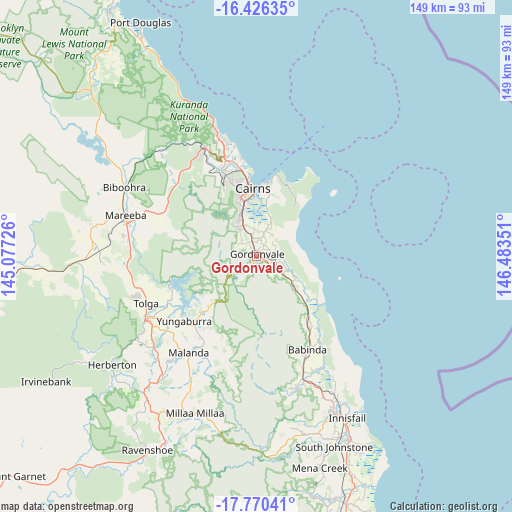
Gordonvale GPS coordinates[2]
17° 5' 58.524" South, 145° 46' 49.368" East
| Map corner | latitude | longitude |
|---|---|---|
| Upper-left | -16.42635°, | 145.07726° |
| Center: | -17.09959°, | 145.78038° |
| Lower-right: | -17.77041°, | 146.48351° |
| Map W x H: | 149.4×149.4 km | = 92.8×92.8mi |
| max Lat: | -10.58257° ⇑3.1% North |
| Gordonvale: | -17.09959° |
| min Lat: | ⇓96.9% South -43.31423° |
| min Long | Gordonvale | max Long |
| 113.53327° | 145.78038° | 153.61246° |
| W 42.1%⇐ | ⇒57.9% E |
Elevation
Elevation of Gordonvale is 21 m = 69 ft, and this is 101 m = 331 ft below average elevation for this country.
| Max E: |
1715 m = 5627 ft | 72.3% |
| Avg. | 122 m = 400 ft | |
| Gordonvale | 21 m = 69 ft | |
Min E: |
-2 m = -7 ft | 27.7% |
See also: Australia elevation on elevation.city.
Geographical zone
Gordonvale is located in South Torrid zone (between Equator and Tropic of Capricorn). Distance of this Southern Tropic circle is 704.6 km =437.8 mi to South.| Distance of | km | miles | from Gordonvale |
|---|---|---|---|
| Equator | 1901.3 | 1181.4 | to North |
| Tropic Capricorn | 704.6 | 437.8 | to South |
| Antarctic Circle | 5499.9 | 3417.5 | to South |
| South Pole | 8105.8 | 5036.7 | to South |


Nearby cities:
15 places around Gordonvale: (largest is in red/bold)
• Aloomba
5.7 km =3.5 mi,  101°
101°
• Bayview Heights
16.3 km =10.1 mi,  339°
339°
• Bentley Park
11.5 km =7.1 mi, 337°
• Bungalow
18.1 km =11.2 mi,  351°
351°
• Cairns
19.6 km =12.2 mi,  355°
355°
• Earlville
17.3 km =10.7 mi, 343°
• Edmonton
9.7 km =6 mi, 336°
• Goldsborough
7.7 km =4.8 mi,  216°
216°
• Mooroobool
19 km =11.8 mi, 344°
• Mount Sheridan
13.6 km =8.5 mi, 338°
• Parramatta Park
19.4 km =12.1 mi, 355°
• Westcourt
19 km =11.8 mi, 351°
• White Rock
14 km =8.7 mi, 352°
• Woree
16.9 km =10.5 mi, 349°
• Yarrabah
17 km =10.6 mi,  46°
46°
Sources, notices
• [Note1] Compared only with cities in Australia existing in our database
• [Src1] Map data: © OpenStreetMap contributors (CC-BY-SA)
• [Src2] Other city data from geonames.org with taken over terms of usage.
• [Src3] Geographical zone / Annual Mean Temperature by Robert A. Rohde @ Wikipedia
