Goldsborough geodata
Goldsborough (Queensland) is a populated place; located in Australia in Australia/Brisbane (GMT+10) time zone. With population of 907 people, there are 3966 cities with bigger population in this country. Compared to other cities in Australia, 96.8% of cities are located further ↓South; 58.2% of cities are located further →East and 72.5% of cities have lower elevation than Goldsborough. Note1


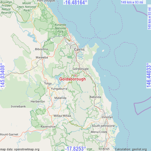
Goldsborough GPS coordinates[2]
17° 9' 16.884" South, 145° 44' 13.92" East
| Map corner | latitude | longitude |
|---|---|---|
| Upper-left | -16.48164°, | 145.03408° |
| Center: | -17.15469°, | 145.7372° |
| Lower-right: | -17.8253°, | 146.44033° |
| Map W x H: | 149.4×149.4 km | = 92.8×92.8mi |
| max Lat: | -10.58257° ⇑3.2% North |
| Goldsborough: | -17.15469° |
| min Lat: | ⇓96.8% South -43.31423° |
| min Long | Goldsborough | max Long |
| 113.53327° | 145.7372° | 153.61246° |
| W 41.8%⇐ | ⇒58.2% E |
Elevation
Elevation of Goldsborough is 115 m = 377 ft, and this is 7 m = 23 ft below average elevation for this country.
| Max E: |
1715 m = 5627 ft | 27.5% |
| Avg. | 122 m = 400 ft | |
| Goldsborough | 115 m = 377 ft | |
Min E: |
-2 m = -7 ft | 72.5% |
See also: Australia elevation on elevation.city.
Geographical zone
Goldsborough is located in South Torrid zone (between Equator and Tropic of Capricorn). Distance of this Southern Tropic circle is 698.5 km =434 mi to South.| Distance of | km | miles | from Goldsborough |
|---|---|---|---|
| Equator | 1907.4 | 1185.2 | to North |
| Tropic Capricorn | 698.5 | 434 | to South |
| Antarctic Circle | 5493.8 | 3413.7 | to South |
| South Pole | 8099.6 | 5032.9 | to South |


Nearby cities:
15 places around Goldsborough: (largest is in red/bold)
• Aloomba
11.4 km =7.1 mi,  64°
64°
• Bayview Heights
21.4 km =13.3 mi,  356°
356°
• Bentley Park
16.8 km =10.4 mi,  0°
0°
• Bungalow
24.1 km =15 mi, 4°
• Earlville
22.7 km =14.1 mi, 358°
• Edmonton
15.1 km =9.4 mi, 2°
• Gordonvale
7.7 km =4.8 mi,  36°
36°
• Mooroobool
24.4 km =15.2 mi, 358°
• Mount Sheridan
18.8 km =11.7 mi, 358°
• Peeramon
21.9 km =13.6 mi,  217°
217°
• Westcourt
25 km =15.5 mi, 3°
• White Rock
20.2 km =12.6 mi,  7°
7°
• Woree
22.8 km =14.2 mi, 3°
• Yarrabah
24.6 km =15.3 mi, 43°
• Yungaburra
20.8 km =12.9 mi,  231°
231°
Sources, notices
• [Note1] Compared only with cities in Australia existing in our database
• [Src1] Map data: © OpenStreetMap contributors (CC-BY-SA)
• [Src2] Other city data from geonames.org with taken over terms of usage.
• [Src3] Geographical zone / Annual Mean Temperature by Robert A. Rohde @ Wikipedia
