Gloucester geodata
Gloucester (New South Wales) is a populated place; located in Australia in Australia/Sydney (GMT+11) time zone. With population of 2,891 people, there are 2321 cities with bigger population in this country. Compared to other cities in Australia, 65% of cities are located further ↓South; 82.4% of cities are located further ←West and 71.7% of cities have lower elevation than Gloucester. Note1


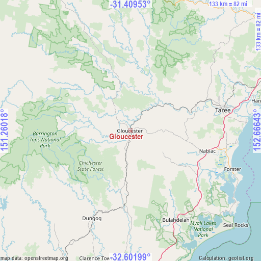
Gloucester GPS coordinates[2]
32° 0' 27.72" South, 151° 57' 47.88" East
| Map corner | latitude | longitude |
|---|---|---|
| Upper-left | -31.40953°, | 151.26018° |
| Center: | -32.0077°, | 151.9633° |
| Lower-right: | -32.60199°, | 152.66643° |
| Map W x H: | 132.6×132.6 km | = 82.4×82.4mi |
| max Lat: | -10.58257° ⇑35% North |
| Gloucester: | -32.0077° |
| min Lat: | ⇓65% South -43.31423° |
| min Long | Gloucester | max Long |
| 113.53327° | 151.9633° | 153.61246° |
| W 82.4%⇐ | ⇒17.6% E |
Elevation
Elevation of Gloucester is 111 m = 364 ft, and this is 11 m = 36 ft below average elevation for this country.
| Max E: |
1715 m = 5627 ft | 28.3% |
| Avg. | 122 m = 400 ft | |
| Gloucester | 111 m = 364 ft | |
Min E: |
-2 m = -7 ft | 71.7% |
See also: Australia elevation on elevation.city.
Geographical zone
Gloucester is located in South temperate zone (between Tropic of Capricorn and the Antarctic Circle). Distance of this Southern Tropic circle is 953 km =592.2 mi to North.| Distance of | km | miles | from Gloucester |
|---|---|---|---|
| Equator | 3558.9 | 2211.4 | to North |
| Tropic Capricorn | 953 | 592.2 | to North |
| Antarctic Circle | 3842.3 | 2387.5 | to South |
| South Pole | 6448.1 | 4006.7 | to South |


Nearby cities:
15 places around Gloucester: (largest is in red/bold)
• Bulahdelah
50.2 km =31.2 mi,  152°
152°
• Coomba Park
53.1 km =33 mi,  118°
118°
• Cundletown
54.1 km =33.6 mi,  76°
76°
• Diamond Beach
54 km =33.6 mi,  94°
94°
• Dungog
48.4 km =30.1 mi,  204°
204°
• Failford
46.4 km =28.8 mi,  101°
101°
• Hallidays Point
51.1 km =31.8 mi, 97°
• Nabiac
40.2 km =25 mi, 104°
• Rainbow Flat
49.1 km =30.5 mi, 93°
• Stroud
44 km =27.3 mi,  179°
179°
• Tallwoods Village
51.8 km =32.2 mi, 95°
• Taree
47.5 km =29.5 mi, 76°
• Tinonee
43.3 km =26.9 mi, 79°
• Tuncurry
53.7 km =33.4 mi,  110°
110°
• Wingham
41.4 km =25.7 mi,  67°
67°
Sources, notices
• [Note1] Compared only with cities in Australia existing in our database
• [Src1] Map data: © OpenStreetMap contributors (CC-BY-SA)
• [Src2] Other city data from geonames.org with taken over terms of usage.
• [Src3] Geographical zone / Annual Mean Temperature by Robert A. Rohde @ Wikipedia
