Stroud geodata
Stroud (New South Wales) is a populated place; located in Australia in Australia/Sydney (GMT+11) time zone. With population of 917 people, there are 3952 cities with bigger population in this country. Compared to other cities in Australia, 61.9% of cities are located further ↓South; 82.5% of cities are located further ←West and 50.4% of cities have higher elevation than Stroud. Note1


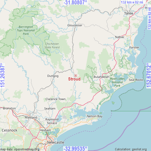
Stroud GPS coordinates[2]
32° 24' 13.176" South, 151° 58' 1.164" East
| Map corner | latitude | longitude |
|---|---|---|
| Upper-left | -31.80807°, | 151.26387° |
| Center: | -32.40366°, | 151.96699° |
| Lower-right: | -32.99535°, | 152.67012° |
| Map W x H: | 132×132 km | = 82×82mi |
| max Lat: | -10.58257° ⇑38.1% North |
| Stroud: | -32.40366° |
| min Lat: | ⇓61.9% South -43.31423° |
| min Long | Stroud | max Long |
| 113.53327° | 151.96699° | 153.61246° |
| W 82.5%⇐ | ⇒17.5% E |
Elevation
Elevation of Stroud is 45 m = 148 ft, and this is 77 m = 253 ft below average elevation for this country.
| Max E: |
1715 m = 5627 ft | 50.4% |
| Avg. | 122 m = 400 ft | |
| Stroud | 45 m = 148 ft | |
Min E: |
-2 m = -7 ft | 49.6% |
See also: Australia elevation on elevation.city.
Geographical zone
Stroud is located in South temperate zone (between Tropic of Capricorn and the Antarctic Circle). Distance of this Southern Tropic circle is 997 km =619.5 mi to North.| Distance of | km | miles | from Stroud |
|---|---|---|---|
| Equator | 3602.9 | 2238.7 | to North |
| Tropic Capricorn | 997 | 619.5 | to North |
| Antarctic Circle | 3798.2 | 2360.1 | to South |
| South Pole | 6404.1 | 3979.3 | to South |


Nearby cities:
15 places around Stroud: (largest is in red/bold)
• Bulahdelah
23 km =14.3 mi,  90°
90°
• Clarence Town
26.8 km =16.7 mi,  221°
221°
• Corlette
37.6 km =23.4 mi,  159°
159°
• Dungog
20.2 km =12.6 mi,  269°
269°
• Hawks Nest
35.4 km =22 mi,  145°
145°
• Karuah
27.8 km =17.3 mi,  181°
181°
• Lemon Tree Passage
37 km =23 mi,  169°
169°
• Mallabula
36.3 km =22.6 mi, 173°
• Medowie
38.7 km =24 mi,  193°
193°
• Nelson Bay
38.9 km =24.2 mi, 154°
• Salamander Bay
37 km =23 mi, 163°
• Seaham
36.5 km =22.7 mi, 218°
• Soldiers Point
35.5 km =22.1 mi, 164°
• Tanilba Bay
38.3 km =23.8 mi, 175°
• Tea Gardens
33.8 km =21 mi, 148°
Sources, notices
• [Note1] Compared only with cities in Australia existing in our database
• [Src1] Map data: © OpenStreetMap contributors (CC-BY-SA)
• [Src2] Other city data from geonames.org with taken over terms of usage.
• [Src3] Geographical zone / Annual Mean Temperature by Robert A. Rohde @ Wikipedia
