Glenhaven geodata
Glenhaven (New South Wales) is a section of populated place; located in Australia in Australia/Sydney (GMT+11) time zone. With population of 6,402 people, there are 1099 cities with bigger population in this country. Compared to other cities in Australia, 51.3% of cities are located further ↓South; 67.6% of cities are located further ←West and 75.7% of cities have lower elevation than Glenhaven. Note1


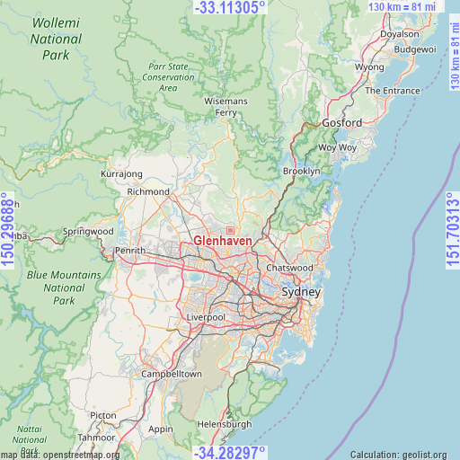
Glenhaven GPS coordinates[2]
33° 42' 0" South, 151° 0' 0" East
| Map corner | latitude | longitude |
|---|---|---|
| Upper-left | -33.11305°, | 150.29688° |
| Center: | -33.7°, | 151° |
| Lower-right: | -34.28297°, | 151.70313° |
| Map W x H: | 130.1×130.1 km | = 80.8×80.8mi |
| max Lat: | -10.58257° ⇑48.7% North |
| Glenhaven: | -33.7° |
| min Lat: | ⇓51.3% South -43.31423° |
| min Long | Glenhaven | max Long |
| 113.53327° | 151° | 153.61246° |
| W 67.6%⇐ | ⇒32.4% E |
Elevation
Elevation of Glenhaven is 137 m = 449 ft, and this is 15 m = 49 ft above average elevation for this country.
| Max E: |
1715 m = 5627 ft | 24.3% |
| Glenhaven | 137 m 449 ft | |
| Avg. | 122 m = 400 ft | |
Min E: |
-2 m = -7 ft | 75.7% |
See also: Australia elevation on elevation.city.
Geographical zone
Glenhaven is located in South temperate zone (between Tropic of Capricorn and the Antarctic Circle). Distance of this Southern Tropic circle is 1141.2 km =709.1 mi to North.| Distance of | km | miles | from Glenhaven |
|---|---|---|---|
| Equator | 3747.1 | 2328.3 | to North |
| Tropic Capricorn | 1141.2 | 709.1 | to North |
| Antarctic Circle | 3654.1 | 2270.6 | to South |
| South Pole | 6260 | 3889.8 | to South |


Nearby cities:
15 places around Glenhaven: (largest is in red/bold)
• Annangrove
6.8 km =4.2 mi,  314°
314°
• Baulkham Hills
6.6 km =4.1 mi,  185°
185°
• Beaumont Hills
5.4 km =3.4 mi,  270°
270°
• Bella Vista
6.2 km =3.9 mi,  222°
222°
• Castle Hill
3.7 km =2.3 mi,  180°
180°
• Cherrybrook
4.9 km =3 mi,  119°
119°
• Dural
2.4 km =1.5 mi,  39°
39°
• Galston
6.8 km =4.2 mi, 39°
• Glenwood
7.2 km =4.5 mi,  239°
239°
• Kellyville
4.7 km =2.9 mi,  255°
255°
• Kenthurst
5 km =3.1 mi,  5°
5°
• Middle Dural
6.9 km =4.3 mi, 13°
• Stanhope Gardens
7.3 km =4.5 mi,  250°
250°
• West Pennant Hills
6.7 km =4.2 mi,  139°
139°
• Westleigh
6.7 km =4.2 mi,  101°
101°
Sources, notices
• [Note1] Compared only with cities in Australia existing in our database
• [Src1] Map data: © OpenStreetMap contributors (CC-BY-SA)
• [Src2] Other city data from geonames.org with taken over terms of usage.
• [Src3] Geographical zone / Annual Mean Temperature by Robert A. Rohde @ Wikipedia
