Dural geodata
Dural (New South Wales) is a section of populated place; located in Australia in Australia/Sydney (GMT+11) time zone. With population of 7,493 people, there are 904 cities with bigger population in this country. Compared to other cities in Australia, 51.6% of cities are located further ↓South; 67.8% of cities are located further ←West and 80.2% of cities have lower elevation than Dural. Note1


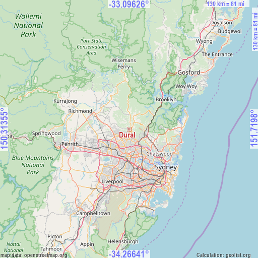
Dural GPS coordinates[2]
33° 40' 59.988" South, 151° 1' 0.012" East
| Map corner | latitude | longitude |
|---|---|---|
| Upper-left | -33.09626°, | 150.31355° |
| Center: | -33.68333°, | 151.01667° |
| Lower-right: | -34.26641°, | 151.7198° |
| Map W x H: | 130.1×130.1 km | = 80.8×80.8mi |
| max Lat: | -10.58257° ⇑48.4% North |
| Dural: | -33.68333° |
| min Lat: | ⇓51.6% South -43.31423° |
| min Long | Dural | max Long |
| 113.53327° | 151.01667° | 153.61246° |
| W 67.8%⇐ | ⇒32.2% E |
Elevation
Elevation of Dural is 184 m = 604 ft, and this is 62 m = 203 ft above average elevation for this country.
| Max E: |
1715 m = 5627 ft | 19.8% |
| Dural | 184 m 604 ft | |
| Avg. | 122 m = 400 ft | |
Min E: |
-2 m = -7 ft | 80.2% |
See also: Australia elevation on elevation.city.
Geographical zone
Dural is located in South temperate zone (between Tropic of Capricorn and the Antarctic Circle). Distance of this Southern Tropic circle is 1139.3 km =707.9 mi to North.| Distance of | km | miles | from Dural |
|---|---|---|---|
| Equator | 3745.2 | 2327.2 | to North |
| Tropic Capricorn | 1139.3 | 707.9 | to North |
| Antarctic Circle | 3655.9 | 2271.7 | to South |
| South Pole | 6261.8 | 3890.9 | to South |


Nearby cities:
15 places around Dural: (largest is in red/bold)
• Annangrove
7 km =4.3 mi,  294°
294°
• Arcadia
7.6 km =4.7 mi,  11°
11°
• Beaumont Hills
7.2 km =4.5 mi,  255°
255°
• Castle Hill
5.8 km =3.6 mi,  195°
195°
• Cherrybrook
5.1 km =3.2 mi,  147°
147°
• Galston
4.4 km =2.7 mi,  39°
39°
• Glenhaven
2.4 km =1.5 mi,  219°
219°
• Hornsby
7.9 km =4.9 mi,  105°
105°
• Hornsby Heights
7.3 km =4.5 mi,  79°
79°
• Kellyville
6.8 km =4.2 mi,  243°
243°
• Kenthurst
3.3 km =2.1 mi,  340°
340°
• Middle Dural
4.8 km =3 mi,  0°
0°
• Thornleigh
7.9 km =4.9 mi,  133°
133°
• West Pennant Hills
7.5 km =4.7 mi,  157°
157°
• Westleigh
6 km =3.7 mi,  121°
121°
Sources, notices
• [Note1] Compared only with cities in Australia existing in our database
• [Src1] Map data: © OpenStreetMap contributors (CC-BY-SA)
• [Src2] Other city data from geonames.org with taken over terms of usage.
• [Src3] Geographical zone / Annual Mean Temperature by Robert A. Rohde @ Wikipedia
