Annangrove geodata
Annangrove (New South Wales) is a section of populated place; located in Australia in Australia/Sydney (GMT+11) time zone. With population of 1,372 people, there are 3393 cities with bigger population in this country. Compared to other cities in Australia, 51.9% of cities are located further ↓South; 66.6% of cities are located further ←West and 64.9% of cities have lower elevation than Annangrove. Note1


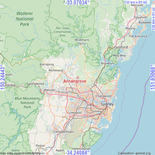
Annangrove GPS coordinates[2]
33° 39' 27.288" South, 150° 56' 51.18" East
| Map corner | latitude | longitude |
|---|---|---|
| Upper-left | -33.07034°, | 150.24443° |
| Center: | -33.65758°, | 150.94755° |
| Lower-right: | -34.24084°, | 151.65068° |
| Map W x H: | 130.1×130.1 km | = 80.8×80.8mi |
| max Lat: | -10.58257° ⇑48.1% North |
| Annangrove: | -33.65758° |
| min Lat: | ⇓51.9% South -43.31423° |
| min Long | Annangrove | max Long |
| 113.53327° | 150.94755° | 153.61246° |
| W 66.6%⇐ | ⇒33.4% E |
Elevation
Elevation of Annangrove is 80 m = 262 ft, and this is 42 m = 138 ft below average elevation for this country.
| Max E: |
1715 m = 5627 ft | 35.1% |
| Avg. | 122 m = 400 ft | |
| Annangrove | 80 m = 262 ft | |
Min E: |
-2 m = -7 ft | 64.9% |
See also: Australia elevation on elevation.city.
Geographical zone
Annangrove is located in South temperate zone (between Tropic of Capricorn and the Antarctic Circle). Distance of this Southern Tropic circle is 1136.5 km =706.2 mi to North.| Distance of | km | miles | from Annangrove |
|---|---|---|---|
| Equator | 3742.4 | 2325.4 | to North |
| Tropic Capricorn | 1136.5 | 706.2 | to North |
| Antarctic Circle | 3658.8 | 2273.5 | to South |
| South Pole | 6264.7 | 3892.7 | to South |


Nearby cities:
15 places around Annangrove: (largest is in red/bold)
• Beaumont Hills
4.7 km =2.9 mi,  187°
187°
• Dural
7 km =4.3 mi,  114°
114°
• Glenhaven
6.8 km =4.2 mi,  134°
134°
• Glenorie
8.4 km =5.2 mi,  42°
42°
• Kellyville
5.9 km =3.7 mi,  176°
176°
• Kellyville Ridge
5.6 km =3.5 mi,  209°
209°
• Kenthurst
5.3 km =3.3 mi,  87°
87°
• Maraylya
7.7 km =4.8 mi,  340°
340°
• Middle Dural
6.7 km =4.2 mi,  73°
73°
• Oakville
7.8 km =4.8 mi,  306°
306°
• Parklea
7.9 km =4.9 mi,  200°
200°
• Riverstone
8 km =5 mi,  249°
249°
• Rouse Hill
4 km =2.5 mi,  227°
227°
• Stanhope Gardens
7.4 km =4.6 mi, 195°
• The Ponds
6 km =3.7 mi, 214°
Sources, notices
• [Note1] Compared only with cities in Australia existing in our database
• [Src1] Map data: © OpenStreetMap contributors (CC-BY-SA)
• [Src2] Other city data from geonames.org with taken over terms of usage.
• [Src3] Geographical zone / Annual Mean Temperature by Robert A. Rohde @ Wikipedia
