Lockrose geodata
Lockrose (Queensland) is a section of populated place; located in Australia in Australia/Brisbane (GMT+10) time zone. With population of 569 people, there are 4649 cities with bigger population in this country. Compared to other cities in Australia, 82.1% of cities are located further ↓South; 84.3% of cities are located further ←West and 63% of cities have lower elevation than Lockrose. Note1


Lockrose GPS coordinates[2]
27° 29' 20.436" South, 152° 27' 36" East
| Map corner | latitude | longitude |
|---|---|---|
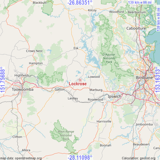
| Upper-left | -26.86351°, | 151.75688° |
| Center: | -27.48901°, | 152.46° |
| Lower-right: | -28.11098°, | 153.16313° |
| Map W x H: | 138.7×138.7 km | = 86.2×86.2mi |
| max Lat: | -10.58257° ⇑17.9% North |
| Lockrose: | -27.48901° |
| min Lat: | ⇓82.1% South -43.31423° |
| min Long | Lockrose | max Long |
| 113.53327° | 152.46° | 153.61246° |
| W 84.3%⇐ | ⇒15.7% E |
Elevation
Elevation of Lockrose is 73 m = 240 ft, and this is 49 m = 161 ft below average elevation for this country.
| Max E: |
1715 m = 5627 ft | 37% |
| Avg. | 122 m = 400 ft | |
| Lockrose | 73 m = 240 ft | |
Min E: |
-2 m = -7 ft | 63% |
See also: Australia elevation on elevation.city.
Geographical zone
Lockrose is located in South temperate zone (between Tropic of Capricorn and the Antarctic Circle). Distance of this Southern Tropic circle is 450.6 km =280 mi to North.| Distance of | km | miles | from Lockrose |
|---|---|---|---|
| Equator | 3056.5 | 1899.2 | to North |
| Tropic Capricorn | 450.6 | 280 | to North |
| Antarctic Circle | 4344.7 | 2699.7 | to South |
| South Pole | 6950.6 | 4318.9 | to South |


Nearby cities:
15 places around Lockrose: (largest is in red/bold)
• Adare
16.4 km =10.2 mi,  260°
260°
• Brightview
2.6 km =1.6 mi,  117°
117°
• Coominya
11.7 km =7.3 mi,  20°
20°
• Forest Hill
15.4 km =9.6 mi,  221°
221°
• Glenore Grove
7.7 km =4.8 mi,  230°
230°
• Hatton Vale
8.7 km =5.4 mi,  175°
175°
• Kensington Grove
5 km =3.1 mi,  166°
166°
• Lockyer Waters
6.6 km =4.1 mi,  306°
306°
• Lowood
11.8 km =7.3 mi,  77°
77°
• Marburg
16 km =9.9 mi, 122°
• Minden
11.5 km =7.1 mi,  133°
133°
• Plainland
9.6 km =6 mi,  206°
206°
• Regency Downs
5.3 km =3.3 mi,  201°
201°
• Spring Creek
13.2 km =8.2 mi,  287°
287°
• Summerholm
14.2 km =8.8 mi, 183°
Sources, notices
• [Note1] Compared only with cities in Australia existing in our database
• [Src1] Map data: © OpenStreetMap contributors (CC-BY-SA)
• [Src2] Other city data from geonames.org with taken over terms of usage.
• [Src3] Geographical zone / Annual Mean Temperature by Robert A. Rohde @ Wikipedia
