Bomaderry geodata
Bomaderry (New South Wales) is a populated place; located in Australia in Australia/Sydney (GMT+11) time zone. With population of 6,499 people, there are 1073 cities with bigger population in this country. Compared to other cities in Australia, 66.6% of cities are located further ↑North; 59.8% of cities are located further ←West and 72.3% of cities have higher elevation than Bomaderry. Note1


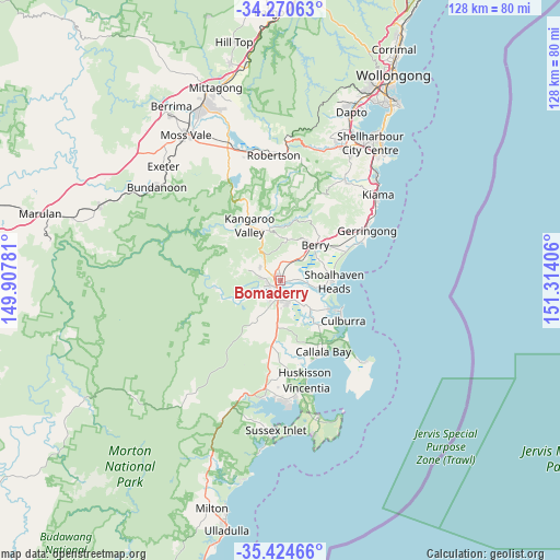
Bomaderry GPS coordinates[2]
34° 50' 58.812" South, 150° 36' 39.348" East
| Map corner | latitude | longitude |
|---|---|---|
| Upper-left | -34.27063°, | 149.90781° |
| Center: | -34.84967°, | 150.61093° |
| Lower-right: | -35.42466°, | 151.31406° |
| Map W x H: | 128.3×128.3 km | = 79.7×79.7mi |
| max Lat: | -10.58257° ⇑66.6% North |
| Bomaderry: | -34.84967° |
| min Lat: | ⇓33.4% South -43.31423° |
| min Long | Bomaderry | max Long |
| 113.53327° | 150.61093° | 153.61246° |
| W 59.8%⇐ | ⇒40.2% E |
Elevation
Elevation of Bomaderry is 21 m = 69 ft, and this is 101 m = 331 ft below average elevation for this country.
| Max E: |
1715 m = 5627 ft | 72.3% |
| Avg. | 122 m = 400 ft | |
| Bomaderry | 21 m = 69 ft | |
Min E: |
-2 m = -7 ft | 27.7% |
See also: Australia elevation on elevation.city.
Geographical zone
Bomaderry is located in South temperate zone (between Tropic of Capricorn and the Antarctic Circle). Distance of this Southern Tropic circle is 1269 km =788.5 mi to North.| Distance of | km | miles | from Bomaderry |
|---|---|---|---|
| Equator | 3874.9 | 2407.8 | to North |
| Tropic Capricorn | 1269 | 788.5 | to North |
| Antarctic Circle | 3526.3 | 2191.1 | to South |
| South Pole | 6132.1 | 3810.3 | to South |


Nearby cities:
15 places around Bomaderry: (largest is in red/bold)
• Berry
11.3 km =7 mi,  42°
42°
• Cambewarra Village
5.5 km =3.4 mi,  301°
301°
• Culburra Beach
16 km =9.9 mi,  123°
123°
• Falls Creek
13 km =8.1 mi,  184°
184°
• Greenwell Point
12.7 km =7.9 mi, 120°
• Kangaroo Valley
14.1 km =8.8 mi,  331°
331°
• North Nowra
3.4 km =2.1 mi,  253°
253°
• Nowra
4 km =2.5 mi,  194°
194°
• Nowra Hill
9.4 km =5.8 mi,  201°
201°
• Orient Point
14.3 km =8.9 mi, 117°
• Shoalhaven Heads
12.2 km =7.6 mi,  90°
90°
• South Nowra
6.1 km =3.8 mi, 190°
• Tapitallee
6.9 km =4.3 mi,  288°
288°
• West Nowra
4.8 km =3 mi,  211°
211°
• Worrigee
6 km =3.7 mi,  159°
159°
Sources, notices
• [Note1] Compared only with cities in Australia existing in our database
• [Src1] Map data: © OpenStreetMap contributors (CC-BY-SA)
• [Src2] Other city data from geonames.org with taken over terms of usage.
• [Src3] Geographical zone / Annual Mean Temperature by Robert A. Rohde @ Wikipedia
