Essendon geodata
Essendon (Victoria) is a section of populated place; located in Australia in Australia/Melbourne (GMT+11) time zone. With population of 20,310 people, there are 162 cities with bigger population in this country. Compared to other cities in Australia, 86% of cities are located further ↑North; 67.8% of cities are located further →East and 51.1% of cities have lower elevation than Essendon. Note1


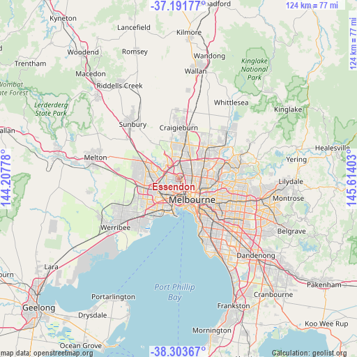
Essendon GPS coordinates[2]
37° 44' 59.316" South, 144° 54' 39.24" East
| Map corner | latitude | longitude |
|---|---|---|
| Upper-left | -37.19177°, | 144.20778° |
| Center: | -37.74981°, | 144.9109° |
| Lower-right: | -38.30367°, | 145.61403° |
| Map W x H: | 123.6×123.6 km | = 76.8×76.8mi |
| max Lat: | -10.58257° ⇑86% North |
| Essendon: | -37.74981° |
| min Lat: | ⇓14% South -43.31423° |
| min Long | Essendon | max Long |
| 113.53327° | 144.9109° | 153.61246° |
| W 32.2%⇐ | ⇒67.8% E |
Elevation
Elevation of Essendon is 47 m = 154 ft, and this is 75 m = 246 ft below average elevation for this country.
| Max E: |
1715 m = 5627 ft | 48.9% |
| Avg. | 122 m = 400 ft | |
| Essendon | 47 m = 154 ft | |
Min E: |
-2 m = -7 ft | 51.1% |
See also: Australia elevation on elevation.city.
Geographical zone
Essendon is located in South temperate zone (between Tropic of Capricorn and the Antarctic Circle). Distance of this Southern Tropic circle is 1591.5 km =988.9 mi to North.| Distance of | km | miles | from Essendon |
|---|---|---|---|
| Equator | 4197.4 | 2608.1 | to North |
| Tropic Capricorn | 1591.5 | 988.9 | to North |
| Antarctic Circle | 3203.8 | 1990.7 | to South |
| South Pole | 5809.7 | 3610 | to South |


Nearby cities:
15 places around Essendon: (largest is in red/bold)
• Aberfeldie
1.6 km =1 mi,  227°
227°
• Airport West
3.8 km =2.4 mi,  316°
316°
• Ascot Vale
3.5 km =2.2 mi,  162°
162°
• Brunswick West
3.3 km =2.1 mi,  119°
119°
• Essendon North
1 km =0.6 mi,  330°
330°
• Essendon West
2.5 km =1.6 mi,  256°
256°
• Maribyrnong
3.4 km =2.1 mi,  222°
222°
• Moonee Ponds
1.9 km =1.2 mi, 164°
• Niddrie
2.1 km =1.3 mi,  309°
309°
• Oak Park
3.6 km =2.2 mi,  12°
12°
• Pascoe Vale
2.7 km =1.7 mi,  47°
47°
• Pascoe Vale South
3.3 km =2.1 mi,  70°
70°
• Strathmore
1.8 km =1.1 mi,  28°
28°
• Strathmore Heights
4.2 km =2.6 mi,  343°
343°
• Travancore
4.1 km =2.5 mi,  147°
147°
Sources, notices
• [Note1] Compared only with cities in Australia existing in our database
• [Src1] Map data: © OpenStreetMap contributors (CC-BY-SA)
• [Src2] Other city data from geonames.org with taken over terms of usage.
• [Src3] Geographical zone / Annual Mean Temperature by Robert A. Rohde @ Wikipedia
