Aberfeldie geodata
Aberfeldie (Victoria) is a section of populated place; located in Australia in Australia/Melbourne (GMT+11) time zone. With population of 3,868 people, there are 1840 cities with bigger population in this country. Compared to other cities in Australia, 86.3% of cities are located further ↑North; 67.9% of cities are located further →East and 59.2% of cities have higher elevation than Aberfeldie. Note1


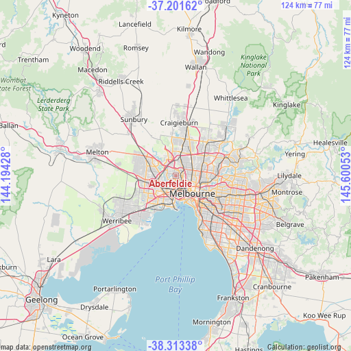
Aberfeldie GPS coordinates[2]
37° 45' 34.524" South, 144° 53' 50.64" East
| Map corner | latitude | longitude |
|---|---|---|
| Upper-left | -37.20162°, | 144.19428° |
| Center: | -37.75959°, | 144.8974° |
| Lower-right: | -38.31338°, | 145.60053° |
| Map W x H: | 123.6×123.6 km | = 76.8×76.8mi |
| max Lat: | -10.58257° ⇑86.3% North |
| Aberfeldie: | -37.75959° |
| min Lat: | ⇓13.7% South -43.31423° |
| min Long | Aberfeldie | max Long |
| 113.53327° | 144.8974° | 153.61246° |
| W 32.1%⇐ | ⇒67.9% E |
Elevation
Elevation of Aberfeldie is 33 m = 108 ft, and this is 89 m = 292 ft below average elevation for this country.
| Max E: |
1715 m = 5627 ft | 59.2% |
| Avg. | 122 m = 400 ft | |
| Aberfeldie | 33 m = 108 ft | |
Min E: |
-2 m = -7 ft | 40.8% |
See also: Australia elevation on elevation.city.
Geographical zone
Aberfeldie is located in South temperate zone (between Tropic of Capricorn and the Antarctic Circle). Distance of this Southern Tropic circle is 1592.6 km =989.6 mi to North.| Distance of | km | miles | from Aberfeldie |
|---|---|---|---|
| Equator | 4198.5 | 2608.8 | to North |
| Tropic Capricorn | 1592.6 | 989.6 | to North |
| Antarctic Circle | 3202.7 | 1990.1 | to South |
| South Pole | 5808.6 | 3609.3 | to South |


Nearby cities:
15 places around Aberfeldie: (largest is in red/bold)
• Airport West
4.1 km =2.5 mi,  339°
339°
• Ascot Vale
3.2 km =2 mi,  135°
135°
• Avondale Heights
3.1 km =1.9 mi,  265°
265°
• Brunswick West
4.1 km =2.5 mi,  97°
97°
• Essendon
1.6 km =1 mi,  47°
47°
• Essendon North
2.1 km =1.3 mi,  20°
20°
• Essendon West
1.3 km =0.8 mi,  292°
292°
• Keilor East
4.1 km =2.5 mi,  316°
316°
• Maidstone
3.1 km =1.9 mi,  222°
222°
• Maribyrnong
1.8 km =1.1 mi, 218°
• Moonee Ponds
1.9 km =1.2 mi,  114°
114°
• Niddrie
2.5 km =1.6 mi,  349°
349°
• Pascoe Vale
4.3 km =2.7 mi, 47°
• Strathmore
3.4 km =2.1 mi,  37°
37°
• Travancore
4.1 km =2.5 mi,  125°
125°
Sources, notices
• [Note1] Compared only with cities in Australia existing in our database
• [Src1] Map data: © OpenStreetMap contributors (CC-BY-SA)
• [Src2] Other city data from geonames.org with taken over terms of usage.
• [Src3] Geographical zone / Annual Mean Temperature by Robert A. Rohde @ Wikipedia
