Maribyrnong geodata
Maribyrnong (Victoria) is a section of populated place; located in Australia in Australia/Melbourne (GMT+11) time zone. With population of 12,086 people, there are 400 cities with bigger population in this country. Compared to other cities in Australia, 86.6% of cities are located further ↑North; 68.1% of cities are located further →East and 53.1% of cities have higher elevation than Maribyrnong. Note1


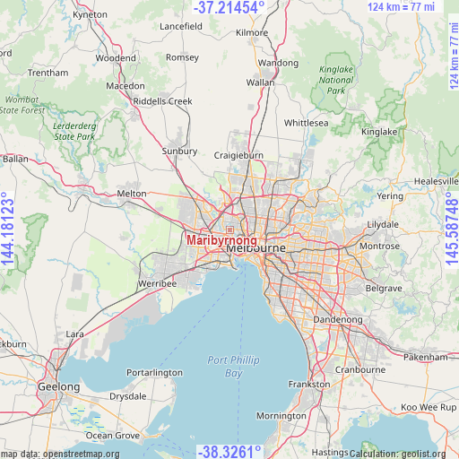
Maribyrnong GPS coordinates[2]
37° 46' 20.676" South, 144° 53' 3.66" East
| Map corner | latitude | longitude |
|---|---|---|
| Upper-left | -37.21454°, | 144.18123° |
| Center: | -37.77241°, | 144.88435° |
| Lower-right: | -38.3261°, | 145.58748° |
| Map W x H: | 123.6×123.6 km | = 76.8×76.8mi |
| max Lat: | -10.58257° ⇑86.6% North |
| Maribyrnong: | -37.77241° |
| min Lat: | ⇓13.4% South -43.31423° |
| min Long | Maribyrnong | max Long |
| 113.53327° | 144.88435° | 153.61246° |
| W 31.9%⇐ | ⇒68.1% E |
Elevation
Elevation of Maribyrnong is 41 m = 135 ft, and this is 81 m = 266 ft below average elevation for this country.
| Max E: |
1715 m = 5627 ft | 53.1% |
| Avg. | 122 m = 400 ft | |
| Maribyrnong | 41 m = 135 ft | |
Min E: |
-2 m = -7 ft | 46.9% |
See also: Australia elevation on elevation.city.
Geographical zone
Maribyrnong is located in South temperate zone (between Tropic of Capricorn and the Antarctic Circle). Distance of this Southern Tropic circle is 1594 km =990.5 mi to North.| Distance of | km | miles | from Maribyrnong |
|---|---|---|---|
| Equator | 4199.9 | 2609.7 | to North |
| Tropic Capricorn | 1594 | 990.5 | to North |
| Antarctic Circle | 3201.3 | 1989.2 | to South |
| South Pole | 5807.2 | 3608.4 | to South |


Nearby cities:
15 places around Maribyrnong: (largest is in red/bold)
• Aberfeldie
1.8 km =1.1 mi,  38°
38°
• Ascot Vale
3.5 km =2.2 mi,  103°
103°
• Avondale Heights
2.3 km =1.4 mi,  302°
302°
• Braybrook
3 km =1.9 mi,  238°
238°
• Essendon
3.4 km =2.1 mi, 42°
• Essendon North
3.8 km =2.4 mi,  28°
28°
• Essendon West
1.9 km =1.2 mi,  357°
357°
• Flemington
4.4 km =2.7 mi,  113°
113°
• Footscray
3.4 km =2.1 mi,  155°
155°
• Kingsville
4 km =2.5 mi,  186°
186°
• Maidstone
1.3 km =0.8 mi,  227°
227°
• Moonee Ponds
2.9 km =1.8 mi,  77°
77°
• Niddrie
3.9 km =2.4 mi,  9°
9°
• Seddon
3.8 km =2.4 mi,  171°
171°
• West Footscray
2.9 km =1.8 mi, 192°
Sources, notices
• [Note1] Compared only with cities in Australia existing in our database
• [Src1] Map data: © OpenStreetMap contributors (CC-BY-SA)
• [Src2] Other city data from geonames.org with taken over terms of usage.
• [Src3] Geographical zone / Annual Mean Temperature by Robert A. Rohde @ Wikipedia
