Enfield geodata
Enfield (Victoria) is a populated place; located in Australia in Australia/Melbourne (GMT+11) time zone. With population of 528 people, there are 4790 cities with bigger population in this country. Compared to other cities in Australia, 85.4% of cities are located further ↑North; 73.2% of cities are located further →East and 90.5% of cities have lower elevation than Enfield. Note1


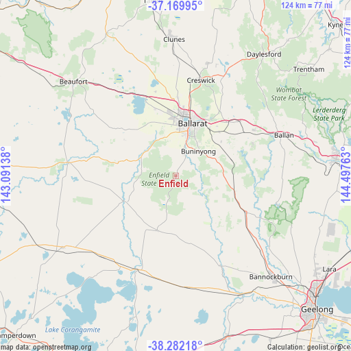
Enfield GPS coordinates[2]
37° 43' 41.34" South, 143° 47' 40.2" East
| Map corner | latitude | longitude |
|---|---|---|
| Upper-left | -37.16995°, | 143.09138° |
| Center: | -37.72815°, | 143.7945° |
| Lower-right: | -38.28218°, | 144.49763° |
| Map W x H: | 123.7×123.7 km | = 76.9×76.9mi |
| max Lat: | -10.58257° ⇑85.4% North |
| Enfield: | -37.72815° |
| min Lat: | ⇓14.6% South -43.31423° |
| min Long | Enfield | max Long |
| 113.53327° | 143.7945° | 153.61246° |
| W 26.8%⇐ | ⇒73.2% E |
Elevation
Elevation of Enfield is 393 m = 1289 ft, and this is 271 m = 889 ft above average elevation for this country.
| Max E: |
1715 m = 5627 ft | 9.5% |
| Enfield | 393 m 1289 ft | |
| Avg. | 122 m = 400 ft | |
Min E: |
-2 m = -7 ft | 90.5% |
See also: Australia elevation on elevation.city.
Geographical zone
Enfield is located in South temperate zone (between Tropic of Capricorn and the Antarctic Circle). Distance of this Southern Tropic circle is 1589.1 km =987.4 mi to North.| Distance of | km | miles | from Enfield |
|---|---|---|---|
| Equator | 4195 | 2606.7 | to North |
| Tropic Capricorn | 1589.1 | 987.4 | to North |
| Antarctic Circle | 3206.2 | 1992.2 | to South |
| South Pole | 5812.1 | 3611.5 | to South |


Nearby cities:
15 places around Enfield: (largest is in red/bold)
• Alfredton
18.1 km =11.2 mi,  6°
6°
• Buninyong
11.7 km =7.3 mi,  42°
42°
• Delacombe
15.6 km =9.7 mi, 6°
• Dereel
10.1 km =6.3 mi,  193°
193°
• Haddon
15.8 km =9.8 mi,  334°
334°
• Mount Clear
16.3 km =10.1 mi,  28°
28°
• Mount Helen
13.7 km =8.5 mi, 32°
• Mount Pleasant
17.3 km =10.7 mi,  21°
21°
• Napoleons
7.6 km =4.7 mi, 26°
• Redan
17.3 km =10.7 mi, 12°
• Ross Creek
9.5 km =5.9 mi,  335°
335°
• Scarsdale
12.5 km =7.8 mi,  295°
295°
• Sebastopol
16.4 km =10.2 mi, 14°
• Smythes Creek
14.3 km =8.9 mi,  356°
356°
• Smythesdale
13.4 km =8.3 mi,  314°
314°
Sources, notices
• [Note1] Compared only with cities in Australia existing in our database
• [Src1] Map data: © OpenStreetMap contributors (CC-BY-SA)
• [Src2] Other city data from geonames.org with taken over terms of usage.
• [Src3] Geographical zone / Annual Mean Temperature by Robert A. Rohde @ Wikipedia
