Buninyong geodata
Buninyong (Victoria) is a populated place; located in Australia in Australia/Melbourne (GMT+11) time zone. With population of 3,568 people, there are 1969 cities with bigger population in this country. Compared to other cities in Australia, 84% of cities are located further ↑North; 72.6% of cities are located further →East and 92.2% of cities have lower elevation than Buninyong. Note1


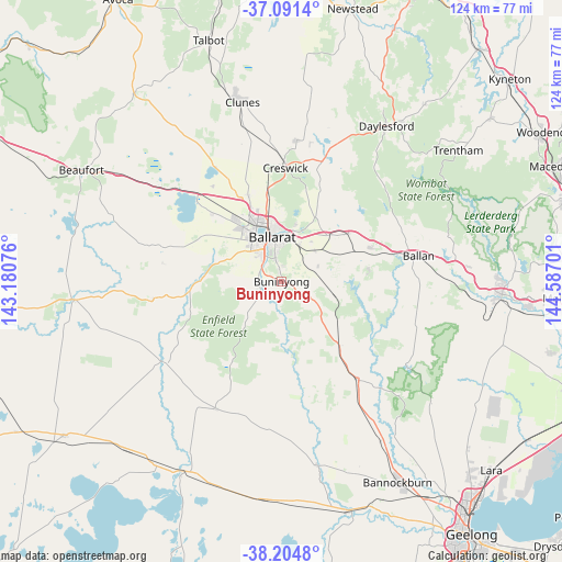
Buninyong GPS coordinates[2]
37° 39' 0.684" South, 143° 53' 1.968" East
| Map corner | latitude | longitude |
|---|---|---|
| Upper-left | -37.0914°, | 143.18076° |
| Center: | -37.65019°, | 143.88388° |
| Lower-right: | -38.2048°, | 144.58701° |
| Map W x H: | 123.8×123.8 km | = 76.9×76.9mi |
| max Lat: | -10.58257° ⇑84% North |
| Buninyong: | -37.65019° |
| min Lat: | ⇓16% South -43.31423° |
| min Long | Buninyong | max Long |
| 113.53327° | 143.88388° | 153.61246° |
| W 27.4%⇐ | ⇒72.6% E |
Elevation
Elevation of Buninyong is 444 m = 1457 ft, and this is 322 m = 1056 ft above average elevation for this country.
| Max E: |
1715 m = 5627 ft | 7.8% |
| Buninyong | 444 m 1457 ft | |
| Avg. | 122 m = 400 ft | |
Min E: |
-2 m = -7 ft | 92.2% |
See also: Australia elevation on elevation.city.
Geographical zone
Buninyong is located in South temperate zone (between Tropic of Capricorn and the Antarctic Circle). Distance of this Southern Tropic circle is 1580.4 km =982 mi to North.| Distance of | km | miles | from Buninyong |
|---|---|---|---|
| Equator | 4186.3 | 2601.2 | to North |
| Tropic Capricorn | 1580.4 | 982 | to North |
| Antarctic Circle | 3214.9 | 1997.6 | to South |
| South Pole | 5820.8 | 3616.9 | to South |


Nearby cities:
15 places around Buninyong: (largest is in red/bold)
• Ballarat
9.8 km =6.1 mi,  342°
342°
• Ballarat Central
10.2 km =6.3 mi, 343°
• Ballarat East
9.4 km =5.8 mi,  350°
350°
• Canadian
8.3 km =5.2 mi,  356°
356°
• Delacombe
9.1 km =5.7 mi,  318°
318°
• Eureka
9.5 km =5.9 mi, 359°
• Golden Point
8.5 km =5.3 mi, 350°
• Mount Clear
5.6 km =3.5 mi, 359°
• Mount Helen
2.9 km =1.8 mi, 351°
• Mount Pleasant
7.6 km =4.7 mi, 348°
• Napoleons
4.8 km =3 mi,  247°
247°
• Redan
9.1 km =5.7 mi,  334°
334°
• Sebastopol
8.2 km =5.1 mi, 331°
• Smythes Creek
10.5 km =6.5 mi,  302°
302°
• Warrenheip
10.3 km =6.4 mi,  25°
25°
Sources, notices
• [Note1] Compared only with cities in Australia existing in our database
• [Src1] Map data: © OpenStreetMap contributors (CC-BY-SA)
• [Src2] Other city data from geonames.org with taken over terms of usage.
• [Src3] Geographical zone / Annual Mean Temperature by Robert A. Rohde @ Wikipedia
