Dunwich geodata
Dunwich (Queensland) is a section of populated place; located in Australia in Australia/Brisbane (GMT+10) time zone. With population of 845 people, there are 4068 cities with bigger population in this country. Compared to other cities in Australia, 82% of cities are located further ↓South; 98.7% of cities are located further ←West and 91.8% of cities have higher elevation than Dunwich. Note1


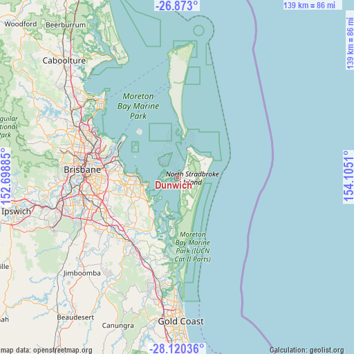
Dunwich GPS coordinates[2]
27° 29' 54.42" South, 153° 24' 7.092" East
| Map corner | latitude | longitude |
|---|---|---|
| Upper-left | -26.873°, | 152.69885° |
| Center: | -27.49845°, | 153.40197° |
| Lower-right: | -28.12036°, | 154.1051° |
| Map W x H: | 138.7×138.7 km | = 86.2×86.2mi |
| max Lat: | -10.58257° ⇑18% North |
| Dunwich: | -27.49845° |
| min Lat: | ⇓82% South -43.31423° |
| min Long | Dunwich | max Long |
| 113.53327° | 153.40197° | 153.61246° |
| W 98.7%⇐ | ⇒1.3% E |
Elevation
Elevation of Dunwich is 8 m = 26 ft, and this is 114 m = 374 ft below average elevation for this country.
| Max E: |
1715 m = 5627 ft | 91.8% |
| Avg. | 122 m = 400 ft | |
| Dunwich | 8 m = 26 ft | |
Min E: |
-2 m = -7 ft | 8.2% |
See also: Australia elevation on elevation.city.
Geographical zone
Dunwich is located in South temperate zone (between Tropic of Capricorn and the Antarctic Circle). Distance of this Southern Tropic circle is 451.6 km =280.6 mi to North.| Distance of | km | miles | from Dunwich |
|---|---|---|---|
| Equator | 3057.5 | 1899.8 | to North |
| Tropic Capricorn | 451.6 | 280.6 | to North |
| Antarctic Circle | 4343.6 | 2699 | to South |
| South Pole | 6949.5 | 4318.2 | to South |


Nearby cities:
15 places around Dunwich: (largest is in red/bold)
• Alexandra Hills
17.5 km =10.9 mi,  257°
257°
• Birkdale
18.4 km =11.4 mi,  275°
275°
• Capalaba
20.3 km =12.6 mi, 255°
• Cleveland
13.9 km =8.6 mi, 256°
• Coochiemudlo Island
10.9 km =6.8 mi,  220°
220°
• Lota
21.6 km =13.4 mi, 278°
• Macleay Island
13.2 km =8.2 mi,  198°
198°
• Ormiston
15.1 km =9.4 mi, 262°
• Point Lookout
15.5 km =9.6 mi,  59°
59°
• Redland Bay
16.1 km =10 mi, 218°
• Russell Island
16.8 km =10.4 mi,  186°
186°
• Thorneside
20.1 km =12.5 mi,  273°
273°
• Thornlands
15 km =9.3 mi,  244°
244°
• Victoria Point
13 km =8.1 mi, 223°
• Wellington Point
15.1 km =9.4 mi, 276°
Sources, notices
• [Note1] Compared only with cities in Australia existing in our database
• [Src1] Map data: © OpenStreetMap contributors (CC-BY-SA)
• [Src2] Other city data from geonames.org with taken over terms of usage.
• [Src3] Geographical zone / Annual Mean Temperature by Robert A. Rohde @ Wikipedia
