Capalaba geodata
Capalaba (Queensland) is a populated place; located in Australia in Australia/Brisbane (GMT+10) time zone. With population of 17,027 people, there are 216 cities with bigger population in this country. Compared to other cities in Australia, 81% of cities are located further ↓South; 96.8% of cities are located further ←West and 80.4% of cities have higher elevation than Capalaba. Note1


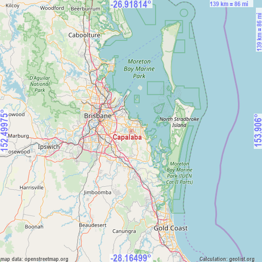
Capalaba GPS coordinates[2]
27° 32' 35.988" South, 153° 12' 10.332" East
| Map corner | latitude | longitude |
|---|---|---|
| Upper-left | -26.91814°, | 152.49975° |
| Center: | -27.54333°, | 153.20287° |
| Lower-right: | -28.16499°, | 153.906° |
| Map W x H: | 138.6×138.6 km | = 86.1×86.1mi |
| max Lat: | -10.58257° ⇑19% North |
| Capalaba: | -27.54333° |
| min Lat: | ⇓81% South -43.31423° |
| min Long | Capalaba | max Long |
| 113.53327° | 153.20287° | 153.61246° |
| W 96.8%⇐ | ⇒3.2% E |
Elevation
Elevation of Capalaba is 15 m = 49 ft, and this is 107 m = 351 ft below average elevation for this country.
| Max E: |
1715 m = 5627 ft | 80.4% |
| Avg. | 122 m = 400 ft | |
| Capalaba | 15 m = 49 ft | |
Min E: |
-2 m = -7 ft | 19.6% |
See also: Australia elevation on elevation.city.
Geographical zone
Capalaba is located in South temperate zone (between Tropic of Capricorn and the Antarctic Circle). Distance of this Southern Tropic circle is 456.6 km =283.7 mi to North.| Distance of | km | miles | from Capalaba |
|---|---|---|---|
| Equator | 3062.5 | 1902.9 | to North |
| Tropic Capricorn | 456.6 | 283.7 | to North |
| Antarctic Circle | 4338.6 | 2695.9 | to South |
| South Pole | 6944.5 | 4315.1 | to South |


Nearby cities:
15 places around Capalaba: (largest is in red/bold)
• Alexandra Hills
2.8 km =1.7 mi,  64°
64°
• Belmont
8.4 km =5.2 mi,  306°
306°
• Birkdale
6.8 km =4.2 mi,  11°
11°
• Burbank
5.7 km =3.5 mi,  255°
255°
• Chandler
6.2 km =3.9 mi,  301°
301°
• Cleveland
6.4 km =4 mi,  73°
73°
• Gumdale
7.5 km =4.7 mi,  319°
319°
• Mackenzie
8.1 km =5 mi,  269°
269°
• Ormiston
5.5 km =3.4 mi, 57°
• Rochedale
7.3 km =4.5 mi,  249°
249°
• Sheldon
4.6 km =2.9 mi,  183°
183°
• Thorneside
6.2 km =3.9 mi,  355°
355°
• Thornlands
6.3 km =3.9 mi,  104°
104°
• Wakerley
8.2 km =5.1 mi,  325°
325°
• Wellington Point
8.1 km =5 mi,  34°
34°
Sources, notices
• [Note1] Compared only with cities in Australia existing in our database
• [Src1] Map data: © OpenStreetMap contributors (CC-BY-SA)
• [Src2] Other city data from geonames.org with taken over terms of usage.
• [Src3] Geographical zone / Annual Mean Temperature by Robert A. Rohde @ Wikipedia
