Creswick geodata
Creswick (Victoria) is a populated place; located in Australia in Australia/Melbourne (GMT+11) time zone. With population of 3,164 people, there are 2153 cities with bigger population in this country. Compared to other cities in Australia, 82.4% of cities are located further ↑North; 72.6% of cities are located further →East and 91.6% of cities have lower elevation than Creswick. Note1


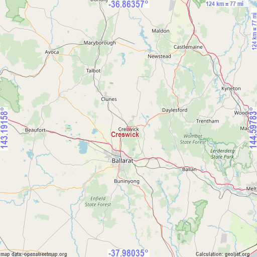
Creswick GPS coordinates[2]
37° 25' 26.544" South, 143° 53' 40.92" East
| Map corner | latitude | longitude |
|---|---|---|
| Upper-left | -36.86357°, | 143.19158° |
| Center: | -37.42404°, | 143.8947° |
| Lower-right: | -37.98035°, | 144.59783° |
| Map W x H: | 124.2×124.2 km | = 77.2×77.2mi |
| max Lat: | -10.58257° ⇑82.4% North |
| Creswick: | -37.42404° |
| min Lat: | ⇓17.6% South -43.31423° |
| min Long | Creswick | max Long |
| 113.53327° | 143.8947° | 153.61246° |
| W 27.4%⇐ | ⇒72.6% E |
Elevation
Elevation of Creswick is 431 m = 1414 ft, and this is 309 m = 1014 ft above average elevation for this country.
| Max E: |
1715 m = 5627 ft | 8.4% |
| Creswick | 431 m 1414 ft | |
| Avg. | 122 m = 400 ft | |
Min E: |
-2 m = -7 ft | 91.6% |
See also: Australia elevation on elevation.city.
Geographical zone
Creswick is located in South temperate zone (between Tropic of Capricorn and the Antarctic Circle). Distance of this Southern Tropic circle is 1555.2 km =966.4 mi to North.| Distance of | km | miles | from Creswick |
|---|---|---|---|
| Equator | 4161.2 | 2585.6 | to North |
| Tropic Capricorn | 1555.2 | 966.4 | to North |
| Antarctic Circle | 3240 | 2013.2 | to South |
| South Pole | 5845.9 | 3632.5 | to South |


Nearby cities:
15 places around Creswick: (largest is in red/bold)
• Ballarat Central
15.8 km =9.8 mi,  194°
194°
• Ballarat East
16.1 km =10 mi, 188°
• Ballarat North
13.2 km =8.2 mi, 190°
• Black Hill
14.2 km =8.8 mi, 190°
• Brown Hill
13.7 km =8.5 mi,  172°
172°
• Eureka
15.7 km =9.8 mi,  183°
183°
• Invermay
10.3 km =6.4 mi, 186°
• Invermay Park
12.3 km =7.6 mi,  195°
195°
• Lake Gardens
15.2 km =9.4 mi,  206°
206°
• Lake Wendouree
14.6 km =9.1 mi, 196°
• Miners Rest
10.4 km =6.5 mi,  232°
232°
• Mitchell Park
13.7 km =8.5 mi, 227°
• Nerrina
14 km =8.7 mi, 184°
• Soldiers Hill
14.3 km =8.9 mi, 192°
• Wendouree
13.2 km =8.2 mi, 206°
Sources, notices
• [Note1] Compared only with cities in Australia existing in our database
• [Src1] Map data: © OpenStreetMap contributors (CC-BY-SA)
• [Src2] Other city data from geonames.org with taken over terms of usage.
• [Src3] Geographical zone / Annual Mean Temperature by Robert A. Rohde @ Wikipedia
