Cressy geodata
Cressy (Tasmania) is a populated place; located in Australia in Australia/Hobart (GMT+11) time zone. With population of 1,077 people, there are 3726 cities with bigger population in this country. Compared to other cities in Australia, 98% of cities are located further ↑North; 52.6% of cities are located further →East and 78.6% of cities have lower elevation than Cressy. Note1


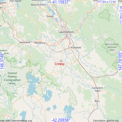
Cressy GPS coordinates[2]
41° 41' 8.196" South, 147° 4' 40.512" East
| Map corner | latitude | longitude |
|---|---|---|
| Upper-left | -41.15837°, | 146.3748° |
| Center: | -41.68561°, | 147.07792° |
| Lower-right: | -42.20856°, | 147.78105° |
| Map W x H: | 116.8×116.8 km | = 72.6×72.6mi |
| max Lat: | -10.58257° ⇑98% North |
| Cressy: | -41.68561° |
| min Lat: | ⇓2% South -43.31423° |
| min Long | Cressy | max Long |
| 113.53327° | 147.07792° | 153.61246° |
| W 47.4%⇐ | ⇒52.6% E |
Elevation
Elevation of Cressy is 164 m = 538 ft, and this is 42 m = 138 ft above average elevation for this country.
| Max E: |
1715 m = 5627 ft | 21.4% |
| Cressy | 164 m 538 ft | |
| Avg. | 122 m = 400 ft | |
Min E: |
-2 m = -7 ft | 78.6% |
See also: Australia elevation on elevation.city.
Geographical zone
Cressy is located in South temperate zone (between Tropic of Capricorn and the Antarctic Circle). Distance of this Southern Tropic circle is 2029.1 km =1260.8 mi to North.| Distance of | km | miles | from Cressy |
|---|---|---|---|
| Equator | 4635 | 2880.1 | to North |
| Tropic Capricorn | 2029.1 | 1260.8 | to North |
| Antarctic Circle | 2766.2 | 1718.8 | to South |
| South Pole | 5372.1 | 3338.1 | to South |


Nearby cities:
15 places around Cressy: (largest is in red/bold)
• Blackstone Heights
25.1 km =15.6 mi,  1°
1°
• Carrick
17.9 km =11.1 mi,  341°
341°
• Evandale
19.5 km =12.1 mi,  48°
48°
• Hadspen
20.6 km =12.8 mi,  358°
358°
• Kings Meadows
24.9 km =15.5 mi,  16°
16°
• Longford
9.6 km =6 mi, 20°
• Norwood
26.6 km =16.5 mi, 18°
• Perth
14.8 km =9.2 mi,  31°
31°
• Prospect Vale
22.9 km =14.2 mi,  5°
5°
• South Launceston
26.2 km =16.3 mi, 12°
• Summerhill
24.6 km =15.3 mi, 9°
• Trevallyn
27.1 km =16.8 mi, 4°
• West Launceston
26.5 km =16.5 mi, 9°
• Westbury
26.4 km =16.4 mi,  311°
311°
• Youngtown
23.8 km =14.8 mi, 18°
Sources, notices
• [Note1] Compared only with cities in Australia existing in our database
• [Src1] Map data: © OpenStreetMap contributors (CC-BY-SA)
• [Src2] Other city data from geonames.org with taken over terms of usage.
• [Src3] Geographical zone / Annual Mean Temperature by Robert A. Rohde @ Wikipedia
