Evandale geodata
Evandale (Tasmania) is a populated place; located in Australia in Australia/Hobart (GMT+11) time zone. With population of 1,303 people, there are 3473 cities with bigger population in this country. Compared to other cities in Australia, 97.9% of cities are located further ↑North; 51.6% of cities are located further →East and 79.6% of cities have lower elevation than Evandale. Note1


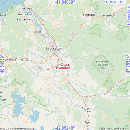
Evandale GPS coordinates[2]
41° 34' 6.888" South, 147° 15' 9.756" East
| Map corner | latitude | longitude |
|---|---|---|
| Upper-left | -41.04039°, | 146.54959° |
| Center: | -41.56858°, | 147.25271° |
| Lower-right: | -42.09249°, | 147.95584° |
| Map W x H: | 117×117 km | = 72.7×72.7mi |
| max Lat: | -10.58257° ⇑97.9% North |
| Evandale: | -41.56858° |
| min Lat: | ⇓2.1% South -43.31423° |
| min Long | Evandale | max Long |
| 113.53327° | 147.25271° | 153.61246° |
| W 48.4%⇐ | ⇒51.6% E |
Elevation
Elevation of Evandale is 177 m = 581 ft, and this is 55 m = 180 ft above average elevation for this country.
| Max E: |
1715 m = 5627 ft | 20.4% |
| Evandale | 177 m 581 ft | |
| Avg. | 122 m = 400 ft | |
Min E: |
-2 m = -7 ft | 79.6% |
See also: Australia elevation on elevation.city.
Geographical zone
Evandale is located in South temperate zone (between Tropic of Capricorn and the Antarctic Circle). Distance of this Southern Tropic circle is 2016.1 km =1252.7 mi to North.| Distance of | km | miles | from Evandale |
|---|---|---|---|
| Equator | 4622 | 2872 | to North |
| Tropic Capricorn | 2016.1 | 1252.7 | to North |
| Antarctic Circle | 2779.2 | 1726.9 | to South |
| South Pole | 5385.1 | 3346.1 | to South |


Nearby cities:
15 places around Evandale: (largest is in red/bold)
• East Launceston
16.8 km =10.4 mi,  329°
329°
• Hadspen
16.7 km =10.4 mi,  296°
296°
• Kings Meadows
13.3 km =8.3 mi, 325°
• Launceston
17.5 km =10.9 mi, 325°
• Longford
11.8 km =7.3 mi,  249°
249°
• Newstead
16.1 km =10 mi, 331°
• Norwood
13.6 km =8.5 mi, 333°
• Perth
6.8 km =4.2 mi,  266°
266°
• Prospect Vale
15.7 km =9.8 mi,  308°
308°
• Saint Leonards
13.2 km =8.2 mi,  340°
340°
• South Launceston
15.5 km =9.6 mi,  324°
324°
• Summerhill
15.3 km =9.5 mi, 317°
• Waverley
15.8 km =9.8 mi, 339°
• West Launceston
16.5 km =10.3 mi, 322°
• Youngtown
11.7 km =7.3 mi, 324°
Sources, notices
• [Note1] Compared only with cities in Australia existing in our database
• [Src1] Map data: © OpenStreetMap contributors (CC-BY-SA)
• [Src2] Other city data from geonames.org with taken over terms of usage.
• [Src3] Geographical zone / Annual Mean Temperature by Robert A. Rohde @ Wikipedia
