Perth geodata
Perth (Tasmania) is a populated place; located in Australia in Australia/Hobart (GMT+11) time zone. With population of 2,907 people, there are 2312 cities with bigger population in this country. Compared to other cities in Australia, 97.9% of cities are located further ↑North; 52.1% of cities are located further →East and 78.8% of cities have lower elevation than Perth. Note1


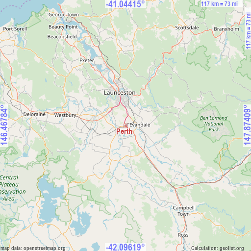
Perth GPS coordinates[2]
41° 34' 20.316" South, 147° 10' 15.456" East
| Map corner | latitude | longitude |
|---|---|---|
| Upper-left | -41.04415°, | 146.46784° |
| Center: | -41.57231°, | 147.17096° |
| Lower-right: | -42.09619°, | 147.87409° |
| Map W x H: | 117×117 km | = 72.7×72.7mi |
| max Lat: | -10.58257° ⇑97.9% North |
| Perth: | -41.57231° |
| min Lat: | ⇓2.1% South -43.31423° |
| min Long | Perth | max Long |
| 113.53327° | 147.17096° | 153.61246° |
| W 47.9%⇐ | ⇒52.1% E |
Elevation
Elevation of Perth is 165 m = 541 ft, and this is 43 m = 141 ft above average elevation for this country.
| Max E: |
1715 m = 5627 ft | 21.2% |
| Perth | 165 m 541 ft | |
| Avg. | 122 m = 400 ft | |
Min E: |
-2 m = -7 ft | 78.8% |
See also: Australia elevation on elevation.city.
Geographical zone
Perth is located in South temperate zone (between Tropic of Capricorn and the Antarctic Circle). Distance of this Southern Tropic circle is 2016.5 km =1253 mi to North.| Distance of | km | miles | from Perth |
|---|---|---|---|
| Equator | 4622.4 | 2872.2 | to North |
| Tropic Capricorn | 2016.5 | 1253 | to North |
| Antarctic Circle | 2778.8 | 1726.7 | to South |
| South Pole | 5384.7 | 3345.9 | to South |


Nearby cities:
15 places around Perth: (largest is in red/bold)
• Blackstone Heights
14.5 km =9 mi,  329°
329°
• Carrick
14.1 km =8.8 mi,  288°
288°
• Cressy
14.8 km =9.2 mi,  211°
211°
• Evandale
6.8 km =4.2 mi,  86°
86°
• Hadspen
11.4 km =7.1 mi,  314°
314°
• Kings Meadows
11.4 km =7.1 mi,  356°
356°
• Longford
5.7 km =3.5 mi,  229°
229°
• Newstead
14.6 km =9.1 mi, 357°
• Norwood
12.6 km =7.8 mi,  3°
3°
• Prospect Vale
11.6 km =7.2 mi, 331°
• Saint Leonards
13.1 km =8.1 mi,  10°
10°
• South Launceston
13.2 km =8.2 mi,  350°
350°
• Summerhill
12.2 km =7.6 mi,  342°
342°
• West Launceston
13.9 km =8.6 mi, 346°
• Youngtown
9.9 km =6.2 mi, 359°
Sources, notices
• [Note1] Compared only with cities in Australia existing in our database
• [Src1] Map data: © OpenStreetMap contributors (CC-BY-SA)
• [Src2] Other city data from geonames.org with taken over terms of usage.
• [Src3] Geographical zone / Annual Mean Temperature by Robert A. Rohde @ Wikipedia
