Longford geodata
Longford (Tasmania) is a populated place; located in Australia in Australia/Hobart (GMT+11) time zone. With population of 3,769 people, there are 1889 cities with bigger population in this country. Compared to other cities in Australia, 98% of cities are located further ↑North; 52.5% of cities are located further →East and 76.6% of cities have lower elevation than Longford. Note1


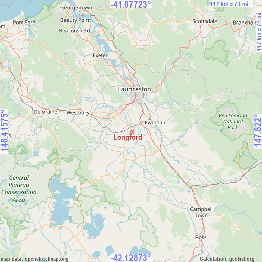
Longford GPS coordinates[2]
41° 36' 18.432" South, 147° 7' 7.932" East
| Map corner | latitude | longitude |
|---|---|---|
| Upper-left | -41.07723°, | 146.41575° |
| Center: | -41.60512°, | 147.11887° |
| Lower-right: | -42.12873°, | 147.822° |
| Map W x H: | 116.9×116.9 km | = 72.6×72.6mi |
| max Lat: | -10.58257° ⇑98% North |
| Longford: | -41.60512° |
| min Lat: | ⇓2% South -43.31423° |
| min Long | Longford | max Long |
| 113.53327° | 147.11887° | 153.61246° |
| W 47.5%⇐ | ⇒52.5% E |
Elevation
Elevation of Longford is 144 m = 472 ft, and this is 22 m = 72 ft above average elevation for this country.
| Max E: |
1715 m = 5627 ft | 23.4% |
| Longford | 144 m 472 ft | |
| Avg. | 122 m = 400 ft | |
Min E: |
-2 m = -7 ft | 76.6% |
See also: Australia elevation on elevation.city.
Geographical zone
Longford is located in South temperate zone (between Tropic of Capricorn and the Antarctic Circle). Distance of this Southern Tropic circle is 2020.1 km =1255.2 mi to North.| Distance of | km | miles | from Longford |
|---|---|---|---|
| Equator | 4626.1 | 2874.5 | to North |
| Tropic Capricorn | 2020.1 | 1255.2 | to North |
| Antarctic Circle | 2775.1 | 1724.4 | to South |
| South Pole | 5381 | 3343.6 | to South |


Nearby cities:
15 places around Longford: (largest is in red/bold)
• Blackstone Heights
16.4 km =10.2 mi,  349°
349°
• Carrick
12.1 km =7.5 mi,  311°
311°
• Cressy
9.6 km =6 mi,  200°
200°
• Evandale
11.8 km =7.3 mi,  69°
69°
• Hadspen
12.2 km =7.6 mi,  342°
342°
• Kings Meadows
15.4 km =9.6 mi,  13°
13°
• Norwood
17 km =10.6 mi,  17°
17°
• Perth
5.7 km =3.5 mi,  49°
49°
• Prospect Vale
13.9 km =8.6 mi, 354°
• Saint Leonards
17.8 km =11.1 mi, 22°
• South Launceston
16.8 km =10.4 mi, 7°
• Summerhill
15.3 km =9.5 mi,  2°
2°
• Trevallyn
18.1 km =11.2 mi,  356°
356°
• West Launceston
17.2 km =10.7 mi, 3°
• Youngtown
14.2 km =8.8 mi, 17°
Sources, notices
• [Note1] Compared only with cities in Australia existing in our database
• [Src1] Map data: © OpenStreetMap contributors (CC-BY-SA)
• [Src2] Other city data from geonames.org with taken over terms of usage.
• [Src3] Geographical zone / Annual Mean Temperature by Robert A. Rohde @ Wikipedia
