Clovelly geodata
Clovelly (New South Wales) is a section of populated place; located in Australia in Australia/Sydney (GMT+11) time zone. With population of 4,648 people, there are 1586 cities with bigger population in this country. Compared to other cities in Australia, 56.5% of cities are located further ↑North; 74.9% of cities are located further ←West and 51.1% of cities have lower elevation than Clovelly. Note1


Clovelly GPS coordinates[2]
33° 54' 43.704" South, 151° 15' 31.752" East
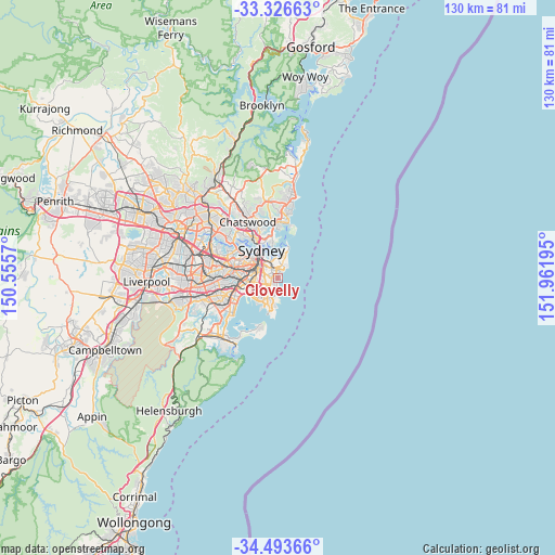
| Map corner | latitude | longitude |
|---|---|---|
| Upper-left | -33.32663°, | 150.5557° |
| Center: | -33.91214°, | 151.25882° |
| Lower-right: | -34.49366°, | 151.96195° |
| Map W x H: | 129.8×129.8 km | = 80.7×80.7mi |
| max Lat: | -10.58257° ⇑56.5% North |
| Clovelly: | -33.91214° |
| min Lat: | ⇓43.5% South -43.31423° |
| min Long | Clovelly | max Long |
| 113.53327° | 151.25882° | 153.61246° |
| W 74.9%⇐ | ⇒25.1% E |
Elevation
Elevation of Clovelly is 47 m = 154 ft, and this is 75 m = 246 ft below average elevation for this country.
| Max E: |
1715 m = 5627 ft | 48.9% |
| Avg. | 122 m = 400 ft | |
| Clovelly | 47 m = 154 ft | |
Min E: |
-2 m = -7 ft | 51.1% |
See also: Australia elevation on elevation.city.
Geographical zone
Clovelly is located in South temperate zone (between Tropic of Capricorn and the Antarctic Circle). Distance of this Southern Tropic circle is 1164.8 km =723.8 mi to North.| Distance of | km | miles | from Clovelly |
|---|---|---|---|
| Equator | 3770.7 | 2343 | to North |
| Tropic Capricorn | 1164.8 | 723.8 | to North |
| Antarctic Circle | 3630.5 | 2255.9 | to South |
| South Pole | 6236.4 | 3875.1 | to South |


Nearby cities:
15 places around Clovelly: (largest is in red/bold)
• Bondi
2.1 km =1.3 mi,  14°
14°
• Bondi Beach
3 km =1.9 mi,  37°
37°
• Bondi Junction
2.4 km =1.5 mi,  333°
333°
• Bronte
1.3 km =0.8 mi,  28°
28°
• Centennial Park
2.8 km =1.7 mi,  304°
304°
• Coogee
1 km =0.6 mi,  199°
199°
• Daceyville
3.6 km =2.2 mi,  238°
238°
• Kensington
3.5 km =2.2 mi,  255°
255°
• Kingsford
3.2 km =2 mi,  245°
245°
• North Bondi
3.4 km =2.1 mi, 36°
• Queens Park
1.8 km =1.1 mi,  322°
322°
• Randwick
0.9 km =0.6 mi, 254°
• South Coogee
2.1 km =1.3 mi,  187°
187°
• Tamarama
1.9 km =1.2 mi, 35°
• Woollahra
3.4 km =2.1 mi, 323°
Sources, notices
• [Note1] Compared only with cities in Australia existing in our database
• [Src1] Map data: © OpenStreetMap contributors (CC-BY-SA)
• [Src2] Other city data from geonames.org with taken over terms of usage.
• [Src3] Geographical zone / Annual Mean Temperature by Robert A. Rohde @ Wikipedia
