Bronte geodata
Bronte (New South Wales) is a section of populated place; located in Australia in Australia/Sydney (GMT+11) time zone. With population of 6,553 people, there are 1062 cities with bigger population in this country. Compared to other cities in Australia, 56.2% of cities are located further ↑North; 75% of cities are located further ←West and 56.9% of cities have higher elevation than Bronte. Note1


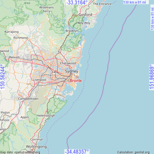
Bronte GPS coordinates[2]
33° 54' 7.128" South, 151° 15' 56.016" East
| Map corner | latitude | longitude |
|---|---|---|
| Upper-left | -33.3164°, | 150.56244° |
| Center: | -33.90198°, | 151.26556° |
| Lower-right: | -34.48357°, | 151.96869° |
| Map W x H: | 129.8×129.8 km | = 80.7×80.7mi |
| max Lat: | -10.58257° ⇑56.2% North |
| Bronte: | -33.90198° |
| min Lat: | ⇓43.8% South -43.31423° |
| min Long | Bronte | max Long |
| 113.53327° | 151.26556° | 153.61246° |
| W 75%⇐ | ⇒25% E |
Elevation
Elevation of Bronte is 36 m = 118 ft, and this is 86 m = 282 ft below average elevation for this country.
| Max E: |
1715 m = 5627 ft | 56.9% |
| Avg. | 122 m = 400 ft | |
| Bronte | 36 m = 118 ft | |
Min E: |
-2 m = -7 ft | 43.1% |
See also: Australia elevation on elevation.city.
Geographical zone
Bronte is located in South temperate zone (between Tropic of Capricorn and the Antarctic Circle). Distance of this Southern Tropic circle is 1163.6 km =723 mi to North.| Distance of | km | miles | from Bronte |
|---|---|---|---|
| Equator | 3769.5 | 2342.3 | to North |
| Tropic Capricorn | 1163.6 | 723 | to North |
| Antarctic Circle | 3631.6 | 2256.6 | to South |
| South Pole | 6237.5 | 3875.8 | to South |


Nearby cities:
15 places around Bronte: (largest is in red/bold)
• Bellevue Hill
2.9 km =1.8 mi,  332°
332°
• Bondi
0.9 km =0.6 mi,  353°
353°
• Bondi Beach
1.7 km =1.1 mi,  43°
43°
• Bondi Junction
2 km =1.2 mi,  301°
301°
• Centennial Park
3 km =1.9 mi,  278°
278°
• Clovelly
1.3 km =0.8 mi,  208°
208°
• Coogee
2.3 km =1.4 mi,  204°
204°
• Double Bay
3.4 km =2.1 mi,  322°
322°
• Edgecliff
3.6 km =2.2 mi,  313°
313°
• North Bondi
2.1 km =1.3 mi, 41°
• Queens Park
1.7 km =1.1 mi, 279°
• Randwick
2.1 km =1.3 mi,  228°
228°
• South Coogee
3.4 km =2.1 mi, 195°
• Tamarama
0.6 km =0.4 mi,  48°
48°
• Woollahra
3.1 km =1.9 mi, 300°
Sources, notices
• [Note1] Compared only with cities in Australia existing in our database
• [Src1] Map data: © OpenStreetMap contributors (CC-BY-SA)
• [Src2] Other city data from geonames.org with taken over terms of usage.
• [Src3] Geographical zone / Annual Mean Temperature by Robert A. Rohde @ Wikipedia
