Cloncurry geodata
Cloncurry (Queensland) is a populated place; located in Australia in Australia/Brisbane (GMT+10) time zone. With population of 3,810 people, there are 1864 cities with bigger population in this country. Compared to other cities in Australia, 94.1% of cities are located further ↓South; 75.9% of cities are located further →East and 81.5% of cities have lower elevation than Cloncurry. Note1


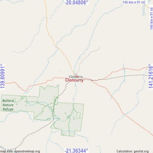
Cloncurry GPS coordinates[2]
20° 42' 25.848" South, 140° 30' 46.908" East
| Map corner | latitude | longitude |
|---|---|---|
| Upper-left | -20.04806°, | 139.80991° |
| Center: | -20.70718°, | 140.51303° |
| Lower-right: | -21.36344°, | 141.21616° |
| Map W x H: | 146.3×146.3 km | = 90.9×90.9mi |
| max Lat: | -10.58257° ⇑5.9% North |
| Cloncurry: | -20.70718° |
| min Lat: | ⇓94.1% South -43.31423° |
| min Long | Cloncurry | max Long |
| 113.53327° | 140.51303° | 153.61246° |
| W 24.1%⇐ | ⇒75.9% E |
Elevation
Elevation of Cloncurry is 197 m = 646 ft, and this is 75 m = 246 ft above average elevation for this country.
| Max E: |
1715 m = 5627 ft | 18.5% |
| Cloncurry | 197 m 646 ft | |
| Avg. | 122 m = 400 ft | |
Min E: |
-2 m = -7 ft | 81.5% |
See also: Australia elevation on elevation.city.
Geographical zone
Cloncurry is located in South Torrid zone (between Equator and Tropic of Capricorn). Distance of this Southern Tropic circle is 303.5 km =188.6 mi to South.| Distance of | km | miles | from Cloncurry |
|---|---|---|---|
| Equator | 2302.4 | 1430.6 | to North |
| Tropic Capricorn | 303.5 | 188.6 | to South |
| Antarctic Circle | 5098.8 | 3168.2 | to South |
| South Pole | 7704.6 | 4787.4 | to South |


Nearby cities:
15 places around Cloncurry: (largest is in red/bold)
• Camooweal
264.4 km =164.3 mi,  289°
289°
• Happy Valley
106.4 km =66.1 mi,  267°
267°
• Healy
105.4 km =65.5 mi, 267°
• Julia Creek
127.9 km =79.5 mi,  87°
87°
• McKinlay
102.7 km =63.8 mi,  127°
127°
• Menzies
105.7 km =65.7 mi, 269°
• Mornington
105.8 km =65.7 mi, 268°
• Mount Isa
105.7 km =65.7 mi, 268°
• Parkside
106.6 km =66.2 mi, 268°
• Pioneer
104.5 km =64.9 mi, 269°
• Richmond
273.6 km =170 mi, 90°
• Soldiers Hill
106.4 km =66.1 mi, 270°
• Sunset
104.5 km =64.9 mi, 269°
• Townview
104.9 km =65.2 mi, 268°
• Winston
105.5 km =65.6 mi, 270°
Sources, notices
• [Note1] Compared only with cities in Australia existing in our database
• [Src1] Map data: © OpenStreetMap contributors (CC-BY-SA)
• [Src2] Other city data from geonames.org with taken over terms of usage.
• [Src3] Geographical zone / Annual Mean Temperature by Robert A. Rohde @ Wikipedia
