Churchill geodata
Churchill (Queensland) is a section of populated place; located in Australia in Australia/Brisbane (GMT+10) time zone. With population of 1,826 people, there are 3024 cities with bigger population in this country. Compared to other cities in Australia, 78.5% of cities are located further ↓South; 86.3% of cities are located further ←West and 50.2% of cities have lower elevation than Churchill. Note1


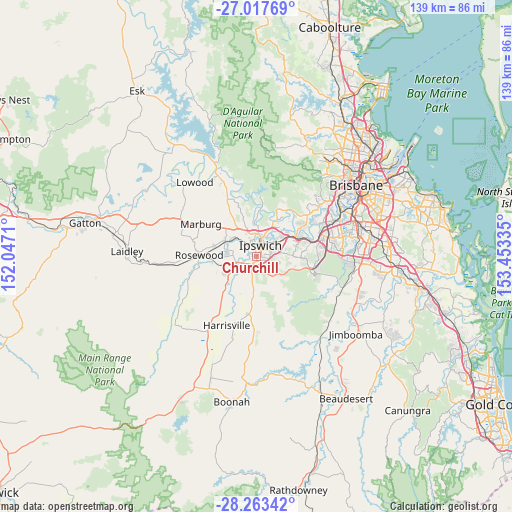
Churchill GPS coordinates[2]
27° 38' 32.388" South, 152° 45' 0.792" East
| Map corner | latitude | longitude |
|---|---|---|
| Upper-left | -27.01769°, | 152.0471° |
| Center: | -27.64233°, | 152.75022° |
| Lower-right: | -28.26342°, | 153.45335° |
| Map W x H: | 138.5×138.5 km | = 86.1×86.1mi |
| max Lat: | -10.58257° ⇑21.5% North |
| Churchill: | -27.64233° |
| min Lat: | ⇓78.5% South -43.31423° |
| min Long | Churchill | max Long |
| 113.53327° | 152.75022° | 153.61246° |
| W 86.3%⇐ | ⇒13.7% E |
Elevation
Elevation of Churchill is 46 m = 151 ft, and this is 76 m = 249 ft below average elevation for this country.
| Max E: |
1715 m = 5627 ft | 49.8% |
| Avg. | 122 m = 400 ft | |
| Churchill | 46 m = 151 ft | |
Min E: |
-2 m = -7 ft | 50.2% |
See also: Australia elevation on elevation.city.
Geographical zone
Churchill is located in South temperate zone (between Tropic of Capricorn and the Antarctic Circle). Distance of this Southern Tropic circle is 467.6 km =290.6 mi to North.| Distance of | km | miles | from Churchill |
|---|---|---|---|
| Equator | 3073.5 | 1909.8 | to North |
| Tropic Capricorn | 467.6 | 290.6 | to North |
| Antarctic Circle | 4327.6 | 2689 | to South |
| South Pole | 6933.5 | 4308.3 | to South |


Nearby cities:
15 places around Churchill: (largest is in red/bold)
• Coalfalls
3.8 km =2.4 mi,  354°
354°
• Deebing Heights
2.8 km =1.7 mi,  183°
183°
• Eastern Heights
3.2 km =2 mi,  60°
60°
• Flinders View
2.6 km =1.6 mi,  110°
110°
• Ipswich
2.3 km =1.4 mi,  26°
26°
• Leichhardt
2.7 km =1.7 mi,  323°
323°
• Newtown
3.9 km =2.4 mi,  42°
42°
• One Mile
1.9 km =1.2 mi, 320°
• Purga
3.9 km =2.4 mi,  241°
241°
• Raceview
2.6 km =1.6 mi,  71°
71°
• Sadliers Crossing
3.3 km =2.1 mi, 352°
• Silkstone
4.4 km =2.7 mi, 57°
• Woodend
4.1 km =2.5 mi,  3°
3°
• Wulkuraka
4.2 km =2.6 mi, 318°
• Yamanto
2.3 km =1.4 mi,  209°
209°
Sources, notices
• [Note1] Compared only with cities in Australia existing in our database
• [Src1] Map data: © OpenStreetMap contributors (CC-BY-SA)
• [Src2] Other city data from geonames.org with taken over terms of usage.
• [Src3] Geographical zone / Annual Mean Temperature by Robert A. Rohde @ Wikipedia
