Eastern Heights geodata
Eastern Heights (Queensland) is a section of populated place; located in Australia in Australia/Brisbane (GMT+10) time zone. With population of 3,662 people, there are 1933 cities with bigger population in this country. Compared to other cities in Australia, 78.8% of cities are located further ↓South; 86.7% of cities are located further ←West and 51.7% of cities have higher elevation than Eastern Heights. Note1


Eastern Heights GPS coordinates[2]
27° 37' 42.564" South, 152° 46' 41.808" East
| Map corner | latitude | longitude |
|---|---|---|
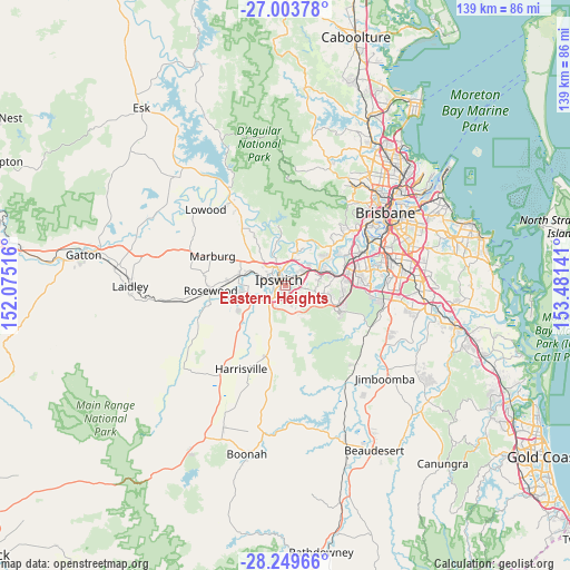
| Upper-left | -27.00378°, | 152.07516° |
| Center: | -27.62849°, | 152.77828° |
| Lower-right: | -28.24966°, | 153.48141° |
| Map W x H: | 138.5×138.5 km | = 86.1×86.1mi |
| max Lat: | -10.58257° ⇑21.2% North |
| Eastern Heights: | -27.62849° |
| min Lat: | ⇓78.8% South -43.31423° |
| min Long | Eastern Heights | max Long |
| 113.53327° | 152.77828° | 153.61246° |
| W 86.7%⇐ | ⇒13.3% E |
Elevation
Elevation of Eastern Heights is 43 m = 141 ft, and this is 79 m = 259 ft below average elevation for this country.
| Max E: |
1715 m = 5627 ft | 51.7% |
| Avg. | 122 m = 400 ft | |
| Eastern Heights | 43 m = 141 ft | |
Min E: |
-2 m = -7 ft | 48.3% |
See also: Australia elevation on elevation.city.
Geographical zone
Eastern Heights is located in South temperate zone (between Tropic of Capricorn and the Antarctic Circle). Distance of this Southern Tropic circle is 466.1 km =289.6 mi to North.| Distance of | km | miles | from Eastern Heights |
|---|---|---|---|
| Equator | 3072 | 1908.9 | to North |
| Tropic Capricorn | 466.1 | 289.6 | to North |
| Antarctic Circle | 4329.2 | 2690 | to South |
| South Pole | 6935.1 | 4309.3 | to South |


Nearby cities:
15 places around Eastern Heights: (largest is in red/bold)
• Basin Pocket
3.3 km =2.1 mi,  347°
347°
• Blackstone
3 km =1.9 mi,  82°
82°
• Booval
2 km =1.2 mi,  33°
33°
• Churchill
3.2 km =2 mi,  240°
240°
• East Ipswich
2.5 km =1.6 mi, 346°
• Flinders View
2.5 km =1.6 mi,  188°
188°
• Ipswich
1.8 km =1.1 mi,  287°
287°
• Moores Pocket
3.4 km =2.1 mi,  358°
358°
• Newtown
1.4 km =0.9 mi, 353°
• North Booval
3.2 km =2 mi, 30°
• North Ipswich
3.3 km =2.1 mi,  329°
329°
• Raceview
0.8 km =0.5 mi,  203°
203°
• Sadliers Crossing
3.7 km =2.3 mi,  299°
299°
• Silkstone
1.2 km =0.7 mi,  49°
49°
• Woodend
3.6 km =2.2 mi,  315°
315°
Sources, notices
• [Note1] Compared only with cities in Australia existing in our database
• [Src1] Map data: © OpenStreetMap contributors (CC-BY-SA)
• [Src2] Other city data from geonames.org with taken over terms of usage.
• [Src3] Geographical zone / Annual Mean Temperature by Robert A. Rohde @ Wikipedia
