Coalfalls geodata
Coalfalls (Queensland) is a section of populated place; located in Australia in Australia/Brisbane (GMT+10) time zone. With population of 922 people, there are 3942 cities with bigger population in this country. Compared to other cities in Australia, 79.3% of cities are located further ↓South; 86.2% of cities are located further ←West and 53.7% of cities have higher elevation than Coalfalls. Note1


Coalfalls GPS coordinates[2]
27° 36' 30.204" South, 152° 44' 48.408" East
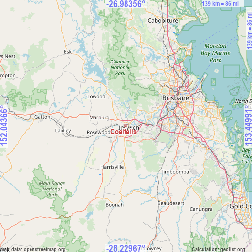
| Map corner | latitude | longitude |
|---|---|---|
| Upper-left | -26.98356°, | 152.04366° |
| Center: | -27.60839°, | 152.74678° |
| Lower-right: | -28.22967°, | 153.44991° |
| Map W x H: | 138.6×138.6 km | = 86.1×86.1mi |
| max Lat: | -10.58257° ⇑20.7% North |
| Coalfalls: | -27.60839° |
| min Lat: | ⇓79.3% South -43.31423° |
| min Long | Coalfalls | max Long |
| 113.53327° | 152.74678° | 153.61246° |
| W 86.2%⇐ | ⇒13.8% E |
Elevation
Elevation of Coalfalls is 40 m = 131 ft, and this is 82 m = 269 ft below average elevation for this country.
| Max E: |
1715 m = 5627 ft | 53.7% |
| Avg. | 122 m = 400 ft | |
| Coalfalls | 40 m = 131 ft | |
Min E: |
-2 m = -7 ft | 46.3% |
See also: Australia elevation on elevation.city.
Geographical zone
Coalfalls is located in South temperate zone (between Tropic of Capricorn and the Antarctic Circle). Distance of this Southern Tropic circle is 463.8 km =288.2 mi to North.| Distance of | km | miles | from Coalfalls |
|---|---|---|---|
| Equator | 3069.8 | 1907.5 | to North |
| Tropic Capricorn | 463.8 | 288.2 | to North |
| Antarctic Circle | 4331.4 | 2691.4 | to South |
| South Pole | 6937.3 | 4310.6 | to South |


Nearby cities:
15 places around Coalfalls: (largest is in red/bold)
• Basin Pocket
2.6 km =1.6 mi,  68°
68°
• Brassall
1.2 km =0.7 mi,  3°
3°
• Churchill
3.8 km =2.4 mi,  174°
174°
• East Ipswich
2.5 km =1.6 mi,  84°
84°
• Eastern Heights
3.8 km =2.4 mi,  125°
125°
• Ipswich
2.2 km =1.4 mi,  140°
140°
• Leichhardt
2.1 km =1.3 mi,  218°
218°
• Moores Pocket
3.2 km =2 mi, 68°
• Newtown
3.1 km =1.9 mi,  106°
106°
• North Ipswich
1.6 km =1 mi, 66°
• One Mile
2.5 km =1.6 mi,  201°
201°
• Sadliers Crossing
0.5 km =0.3 mi,  192°
192°
• Tivoli
2.7 km =1.7 mi,  50°
50°
• Woodend
0.7 km =0.4 mi,  62°
62°
• Wulkuraka
2.5 km =1.6 mi,  255°
255°
Sources, notices
• [Note1] Compared only with cities in Australia existing in our database
• [Src1] Map data: © OpenStreetMap contributors (CC-BY-SA)
• [Src2] Other city data from geonames.org with taken over terms of usage.
• [Src3] Geographical zone / Annual Mean Temperature by Robert A. Rohde @ Wikipedia
