Newtown geodata
Newtown (Queensland) is a section of populated place; located in Australia in Australia/Brisbane (GMT+10) time zone. With population of 1,590 people, there are 3198 cities with bigger population in this country. Compared to other cities in Australia, 79% of cities are located further ↓South; 86.6% of cities are located further ←West and 53.1% of cities have higher elevation than Newtown. Note1


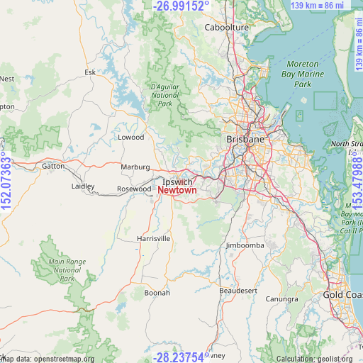
Newtown GPS coordinates[2]
27° 36' 58.68" South, 152° 46' 36.3" East
| Map corner | latitude | longitude |
|---|---|---|
| Upper-left | -26.99152°, | 152.07363° |
| Center: | -27.6163°, | 152.77675° |
| Lower-right: | -28.23754°, | 153.47988° |
| Map W x H: | 138.5×138.5 km | = 86.1×86.1mi |
| max Lat: | -10.58257° ⇑21% North |
| Newtown: | -27.6163° |
| min Lat: | ⇓79% South -43.31423° |
| min Long | Newtown | max Long |
| 113.53327° | 152.77675° | 153.61246° |
| W 86.6%⇐ | ⇒13.4% E |
Elevation
Elevation of Newtown is 41 m = 135 ft, and this is 81 m = 266 ft below average elevation for this country.
| Max E: |
1715 m = 5627 ft | 53.1% |
| Avg. | 122 m = 400 ft | |
| Newtown | 41 m = 135 ft | |
Min E: |
-2 m = -7 ft | 46.9% |
See also: Australia elevation on elevation.city.
Geographical zone
Newtown is located in South temperate zone (between Tropic of Capricorn and the Antarctic Circle). Distance of this Southern Tropic circle is 464.7 km =288.8 mi to North.| Distance of | km | miles | from Newtown |
|---|---|---|---|
| Equator | 3070.6 | 1908 | to North |
| Tropic Capricorn | 464.7 | 288.8 | to North |
| Antarctic Circle | 4330.5 | 2690.8 | to South |
| South Pole | 6936.4 | 4310.1 | to South |


Nearby cities:
15 places around Newtown: (largest is in red/bold)
• Basin Pocket
1.9 km =1.2 mi,  343°
343°
• Blackstone
3.3 km =2.1 mi,  107°
107°
• Booval
1.3 km =0.8 mi,  74°
74°
• Coalfalls
3.1 km =1.9 mi,  286°
286°
• East Ipswich
1.2 km =0.7 mi, 338°
• Eastern Heights
1.4 km =0.9 mi,  173°
173°
• Ipswich
1.8 km =1.1 mi,  243°
243°
• Moores Pocket
2.1 km =1.3 mi,  1°
1°
• North Booval
2.3 km =1.4 mi,  52°
52°
• North Ipswich
2.1 km =1.3 mi,  314°
314°
• Raceview
2.1 km =1.3 mi,  184°
184°
• Sadliers Crossing
3.1 km =1.9 mi,  277°
277°
• Silkstone
1.2 km =0.7 mi,  117°
117°
• Tivoli
2.8 km =1.7 mi, 341°
• Woodend
2.6 km =1.6 mi,  297°
297°
Sources, notices
• [Note1] Compared only with cities in Australia existing in our database
• [Src1] Map data: © OpenStreetMap contributors (CC-BY-SA)
• [Src2] Other city data from geonames.org with taken over terms of usage.
• [Src3] Geographical zone / Annual Mean Temperature by Robert A. Rohde @ Wikipedia
