Woolwich geodata
Woolwich (New South Wales) is a section of populated place; located in Australia in Australia/Sydney (GMT+11) time zone. With population of 798 people, there are 4151 cities with bigger population in this country. Compared to other cities in Australia, 53.3% of cities are located further ↑North; 72.4% of cities are located further ←West and 64.8% of cities have higher elevation than Woolwich. Note1


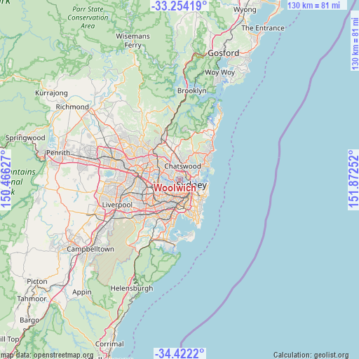
Woolwich GPS coordinates[2]
33° 50' 24.684" South, 151° 10' 9.804" East
| Map corner | latitude | longitude |
|---|---|---|
| Upper-left | -33.25419°, | 150.46627° |
| Center: | -33.84019°, | 151.16939° |
| Lower-right: | -34.4222°, | 151.87252° |
| Map W x H: | 129.9×129.9 km | = 80.7×80.7mi |
| max Lat: | -10.58257° ⇑53.3% North |
| Woolwich: | -33.84019° |
| min Lat: | ⇓46.7% South -43.31423° |
| min Long | Woolwich | max Long |
| 113.53327° | 151.16939° | 153.61246° |
| W 72.4%⇐ | ⇒27.6% E |
Elevation
Elevation of Woolwich is 27 m = 89 ft, and this is 95 m = 312 ft below average elevation for this country.
| Max E: |
1715 m = 5627 ft | 64.8% |
| Avg. | 122 m = 400 ft | |
| Woolwich | 27 m = 89 ft | |
Min E: |
-2 m = -7 ft | 35.2% |
See also: Australia elevation on elevation.city.
Geographical zone
Woolwich is located in South temperate zone (between Tropic of Capricorn and the Antarctic Circle). Distance of this Southern Tropic circle is 1156.8 km =718.8 mi to North.| Distance of | km | miles | from Woolwich |
|---|---|---|---|
| Equator | 3762.7 | 2338 | to North |
| Tropic Capricorn | 1156.8 | 718.8 | to North |
| Antarctic Circle | 3638.5 | 2260.9 | to South |
| South Pole | 6244.4 | 3880.1 | to South |


Nearby cities:
15 places around Woolwich: (largest is in red/bold)
• Artarmon
2.9 km =1.8 mi,  26°
26°
• Balmain
2.1 km =1.3 mi,  141°
141°
• Balmain East
2.9 km =1.8 mi,  130°
130°
• Birchgrove
1.8 km =1.1 mi, 136°
• Drummoyne
1.9 km =1.2 mi,  224°
224°
• Greenwich
1.3 km =0.8 mi,  86°
86°
• Hunters Hill
2.3 km =1.4 mi,  286°
286°
• Huntleys Cove
2.9 km =1.8 mi,  274°
274°
• Lane Cove
2.7 km =1.7 mi,  354°
354°
• Longueville
0.9 km =0.6 mi,  335°
335°
• Northwood
1.6 km =1 mi,  38°
38°
• Riverview
1.8 km =1.1 mi, 339°
• Rozelle
2.4 km =1.5 mi,  177°
177°
• Waverton
2.9 km =1.8 mi, 86°
• Wollstonecraft
2.1 km =1.3 mi,  66°
66°
Sources, notices
• [Note1] Compared only with cities in Australia existing in our database
• [Src1] Map data: © OpenStreetMap contributors (CC-BY-SA)
• [Src2] Other city data from geonames.org with taken over terms of usage.
• [Src3] Geographical zone / Annual Mean Temperature by Robert A. Rohde @ Wikipedia
