Avondale geodata
Avondale (Queensland) is a populated place; located in Australia in Australia/Brisbane (GMT+10) time zone. With population of 603 people, there are 4557 cities with bigger population in this country. Compared to other cities in Australia, 90.4% of cities are located further ↓South; 83.2% of cities are located further ←West and 69.8% of cities have higher elevation than Avondale. Note1


Avondale GPS coordinates[2]
24° 44' 17.736" South, 152° 9' 29.664" East
| Map corner | latitude | longitude |
|---|---|---|
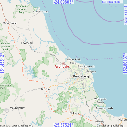
| Upper-left | -24.09803°, | 151.45512° |
| Center: | -24.73826°, | 152.15824° |
| Lower-right: | -25.37521°, | 152.86137° |
| Map W x H: | 142×142 km | = 88.2×88.2mi |
| max Lat: | -10.58257° ⇑9.6% North |
| Avondale: | -24.73826° |
| min Lat: | ⇓90.4% South -43.31423° |
| min Long | Avondale | max Long |
| 113.53327° | 152.15824° | 153.61246° |
| W 83.2%⇐ | ⇒16.8% E |
Elevation
Elevation of Avondale is 23 m = 75 ft, and this is 99 m = 325 ft below average elevation for this country.
| Max E: |
1715 m = 5627 ft | 69.8% |
| Avg. | 122 m = 400 ft | |
| Avondale | 23 m = 75 ft | |
Min E: |
-2 m = -7 ft | 30.2% |
See also: Australia elevation on elevation.city.
Geographical zone
Avondale is located in South temperate zone (between Tropic of Capricorn and the Antarctic Circle). Distance of this Southern Tropic circle is 144.7 km =89.9 mi to North.| Distance of | km | miles | from Avondale |
|---|---|---|---|
| Equator | 2750.6 | 1709.1 | to North |
| Tropic Capricorn | 144.7 | 89.9 | to North |
| Antarctic Circle | 4650.5 | 2889.7 | to South |
| South Pole | 7256.4 | 4508.9 | to South |


Nearby cities:
15 places around Avondale: (largest is in red/bold)
• Avoca
21.7 km =13.5 mi,  135°
135°
• Branyan
22.6 km =14 mi,  149°
149°
• Bucca
15.4 km =9.6 mi,  202°
202°
• Bundaberg
23.9 km =14.9 mi,  126°
126°
• Bundaberg North
22.6 km =14 mi,  122°
122°
• Bundaberg South
25.3 km =15.7 mi, 126°
• Bundaberg West
23.4 km =14.5 mi, 129°
• Gooburrum
19.9 km =12.4 mi, 118°
• Kensington
25.6 km =15.9 mi, 140°
• Millbank
22.5 km =14 mi, 132°
• Moore Park Beach
6 km =3.7 mi,  59°
59°
• Norville
25.2 km =15.7 mi, 133°
• Sharon
19 km =11.8 mi, 143°
• South Kolan
21.6 km =13.4 mi,  177°
177°
• Svensson Heights
24 km =14.9 mi, 133°
Sources, notices
• [Note1] Compared only with cities in Australia existing in our database
• [Src1] Map data: © OpenStreetMap contributors (CC-BY-SA)
• [Src2] Other city data from geonames.org with taken over terms of usage.
• [Src3] Geographical zone / Annual Mean Temperature by Robert A. Rohde @ Wikipedia
