Moore Park Beach geodata
Moore Park Beach (Queensland) is a populated locality; located in Australia in Australia/Brisbane (GMT+10) time zone. With population of 2,661 people, there are 2458 cities with bigger population in this country. Compared to other cities in Australia, 90.4% of cities are located further ↓South; 83.3% of cities are located further ←West and 72.3% of cities have higher elevation than Moore Park Beach. Note1


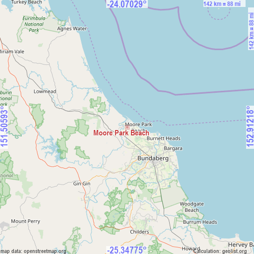
Moore Park Beach GPS coordinates[2]
24° 42' 38.376" South, 152° 12' 32.58" East
| Map corner | latitude | longitude |
|---|---|---|
| Upper-left | -24.07029°, | 151.50593° |
| Center: | -24.71066°, | 152.20905° |
| Lower-right: | -25.34775°, | 152.91218° |
| Map W x H: | 142×142 km | = 88.2×88.2mi |
| max Lat: | -10.58257° ⇑9.6% North |
| Moore Park Beach: | -24.71066° |
| min Lat: | ⇓90.4% South -43.31423° |
| min Long | Moore Park Beac | max Long |
| 113.53327° | 152.20905° | 153.61246° |
| W 83.3%⇐ | ⇒16.7% E |
Elevation
Elevation of Moore Park Beach is 21 m = 69 ft, and this is 101 m = 331 ft below average elevation for this country.
| Max E: |
1715 m = 5627 ft | 72.3% |
| Avg. | 122 m = 400 ft | |
| Moore Park Beach | 21 m = 69 ft | |
Min E: |
-2 m = -7 ft | 27.7% |
See also: Australia elevation on elevation.city.
Geographical zone
Moore Park Beach is located in South temperate zone (between Tropic of Capricorn and the Antarctic Circle). Distance of this Southern Tropic circle is 141.6 km =88 mi to North.| Distance of | km | miles | from Moore Park Beach |
|---|---|---|---|
| Equator | 2747.6 | 1707.3 | to North |
| Tropic Capricorn | 141.6 | 88 | to North |
| Antarctic Circle | 4653.6 | 2891.6 | to South |
| South Pole | 7259.5 | 4510.8 | to South |


Nearby cities:
15 places around Moore Park Beach: (largest is in red/bold)
• Avoca
21.1 km =13.1 mi,  151°
151°
• Avondale
6 km =3.7 mi,  239°
239°
• Branyan
23.4 km =14.5 mi,  164°
164°
• Bucca
20.5 km =12.7 mi,  212°
212°
• Bundaberg
22.3 km =13.9 mi,  140°
140°
• Bundaberg East
23.8 km =14.8 mi,  133°
133°
• Bundaberg North
20.7 km =12.9 mi, 138°
• Bundaberg South
23.6 km =14.7 mi, 139°
• Bundaberg West
22.1 km =13.7 mi, 144°
• Burnett Heads
21.4 km =13.3 mi,  106°
106°
• Gooburrum
17.6 km =10.9 mi, 135°
• Kalkie
23.2 km =14.4 mi, 129°
• Millbank
21.6 km =13.4 mi, 148°
• Sharon
19.4 km =12.1 mi, 161°
• Svensson Heights
23.1 km =14.4 mi, 147°
Sources, notices
• [Note1] Compared only with cities in Australia existing in our database
• [Src1] Map data: © OpenStreetMap contributors (CC-BY-SA)
• [Src2] Other city data from geonames.org with taken over terms of usage.
• [Src3] Geographical zone / Annual Mean Temperature by Robert A. Rohde @ Wikipedia
