Yarrawarrah geodata
Yarrawarrah (New South Wales) is a section of populated place; located in Australia in Australia/Sydney (GMT+10) time zone. With population of 2,691 people, there are 2438 cities with bigger population in this country. Compared to other cities in Australia, 60.1% of cities are located further ↑North; 68.3% of cities are located further ←West and 73.5% of cities have lower elevation than Yarrawarrah. Note1


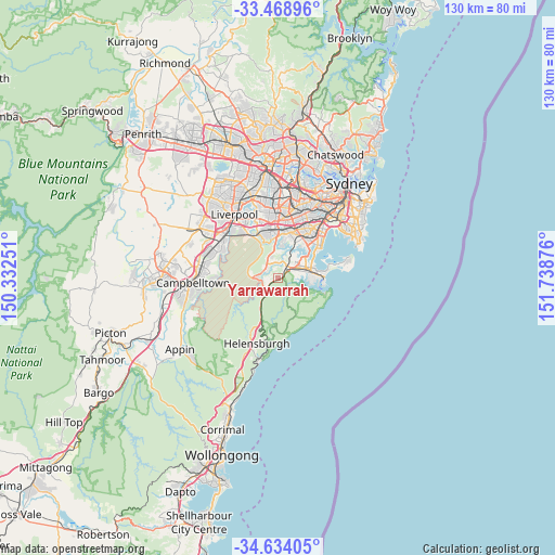
Yarrawarrah GPS coordinates[2]
34° 3' 12.636" South, 151° 2' 8.268" East
| Map corner | latitude | longitude |
|---|---|---|
| Upper-left | -33.46896°, | 150.33251° |
| Center: | -34.05351°, | 151.03563° |
| Lower-right: | -34.63405°, | 151.73876° |
| Map W x H: | 129.5×129.5 km | = 80.5×80.5mi |
| max Lat: | -10.58257° ⇑60.1% North |
| Yarrawarrah: | -34.05351° |
| min Lat: | ⇓39.9% South -43.31423° |
| min Long | Yarrawarrah | max Long |
| 113.53327° | 151.03563° | 153.61246° |
| W 68.3%⇐ | ⇒31.7% E |
Elevation
Elevation of Yarrawarrah is 120 m = 394 ft, and this is 2 m = 7 ft below average elevation for this country.
| Max E: |
1715 m = 5627 ft | 26.5% |
| Avg. | 122 m = 400 ft | |
| Yarrawarrah | 120 m = 394 ft | |
Min E: |
-2 m = -7 ft | 73.5% |
See also: Australia elevation on elevation.city.
Geographical zone
Yarrawarrah is located in South temperate zone (between Tropic of Capricorn and the Antarctic Circle). Distance of this Southern Tropic circle is 1180.5 km =733.5 mi to North.| Distance of | km | miles | from Yarrawarrah |
|---|---|---|---|
| Equator | 3786.4 | 2352.8 | to North |
| Tropic Capricorn | 1180.5 | 733.5 | to North |
| Antarctic Circle | 3614.8 | 2246.1 | to South |
| South Pole | 6220.7 | 3865.4 | to South |


Nearby cities:
15 places around Yarrawarrah: (largest is in red/bold)
• Bangor
4.1 km =2.5 mi,  357°
357°
• Barden Ridge
3.1 km =1.9 mi,  314°
314°
• Bonnet Bay
5.1 km =3.2 mi,  17°
17°
• Engadine
2.5 km =1.6 mi,  237°
237°
• Grays Point
4.7 km =2.9 mi,  97°
97°
• Gymea
5 km =3.1 mi,  67°
67°
• Gymea Bay
4.8 km =3 mi,  88°
88°
• Heathcote
4 km =2.5 mi,  211°
211°
• Jannali
4.7 km =2.9 mi,  29°
29°
• Kirrawee
3.5 km =2.2 mi,  61°
61°
• Loftus
1.4 km =0.9 mi,  45°
45°
• Menai
4.5 km =2.8 mi,  336°
336°
• Sutherland
3.1 km =1.9 mi,  35°
35°
• Woronora
3.3 km =2.1 mi,  4°
4°
• Woronora Heights
2.1 km =1.3 mi, 338°
Sources, notices
• [Note1] Compared only with cities in Australia existing in our database
• [Src1] Map data: © OpenStreetMap contributors (CC-BY-SA)
• [Src2] Other city data from geonames.org with taken over terms of usage.
• [Src3] Geographical zone / Annual Mean Temperature by Robert A. Rohde @ Wikipedia
