Monterey geodata
Monterey (New South Wales) is a section of populated place; located in Australia in Australia/Sydney (GMT+10) time zone. With population of 4,451 people, there are 1637 cities with bigger population in this country. Compared to other cities in Australia, 58.4% of cities are located further ↑North; 71.7% of cities are located further ←West and 96.8% of cities have higher elevation than Monterey. Note1


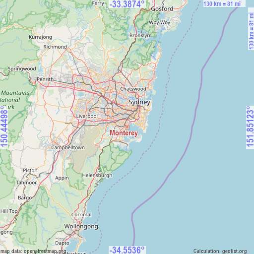
Monterey GPS coordinates[2]
33° 58' 21" South, 151° 8' 53.16" East
| Map corner | latitude | longitude |
|---|---|---|
| Upper-left | -33.3874°, | 150.44498° |
| Center: | -33.9725°, | 151.1481° |
| Lower-right: | -34.5536°, | 151.85123° |
| Map W x H: | 129.7×129.7 km | = 80.6×80.6mi |
| max Lat: | -10.58257° ⇑58.4% North |
| Monterey: | -33.9725° |
| min Lat: | ⇓41.6% South -43.31423° |
| min Long | Monterey | max Long |
| 113.53327° | 151.1481° | 153.61246° |
| W 71.7%⇐ | ⇒28.3% E |
Elevation
Elevation of Monterey is 5 m = 16 ft, and this is 117 m = 384 ft below average elevation for this country.
| Max E: |
1715 m = 5627 ft | 96.8% |
| Avg. | 122 m = 400 ft | |
| Monterey | 5 m = 16 ft | |
Min E: |
-2 m = -7 ft | 3.2% |
See also: Australia elevation on elevation.city.
Geographical zone
Monterey is located in South temperate zone (between Tropic of Capricorn and the Antarctic Circle). Distance of this Southern Tropic circle is 1171.5 km =727.9 mi to North.| Distance of | km | miles | from Monterey |
|---|---|---|---|
| Equator | 3777.4 | 2347.2 | to North |
| Tropic Capricorn | 1171.5 | 727.9 | to North |
| Antarctic Circle | 3623.8 | 2251.7 | to South |
| South Pole | 6229.7 | 3871 | to South |


Nearby cities:
15 places around Monterey: (largest is in red/bold)
• Allawah
3.1 km =1.9 mi,  269°
269°
• Banksia
3 km =1.9 mi,  350°
350°
• Beverley Park
1.4 km =0.9 mi,  248°
248°
• Brighton-Le-Sands
1.4 km =0.9 mi,  11°
11°
• Carlton
2.5 km =1.6 mi, 273°
• Carss Park
3.2 km =2 mi,  240°
240°
• Dolls Point
2.3 km =1.4 mi,  187°
187°
• Kogarah
1.2 km =0.7 mi,  293°
293°
• Kogarah Bay
2.6 km =1.6 mi, 252°
• Kyeemagh
2.7 km =1.7 mi,  28°
28°
• Ramsgate
1.3 km =0.8 mi,  214°
214°
• Ramsgate Beach
1.4 km =0.9 mi, 186°
• Rockdale
2.8 km =1.7 mi,  331°
331°
• Sandringham
2.6 km =1.6 mi,  198°
198°
• Sans Souci
2.4 km =1.5 mi,  215°
215°
Sources, notices
• [Note1] Compared only with cities in Australia existing in our database
• [Src1] Map data: © OpenStreetMap contributors (CC-BY-SA)
• [Src2] Other city data from geonames.org with taken over terms of usage.
• [Src3] Geographical zone / Annual Mean Temperature by Robert A. Rohde @ Wikipedia
