Beverley Park geodata
Beverley Park (New South Wales) is a section of populated place; located in Australia in Australia/Sydney (GMT+10) time zone. With population of 2,430 people, there are 2609 cities with bigger population in this country. Compared to other cities in Australia, 58.4% of cities are located further ↑North; 71.2% of cities are located further ←West and 90.1% of cities have higher elevation than Beverley Park. Note1


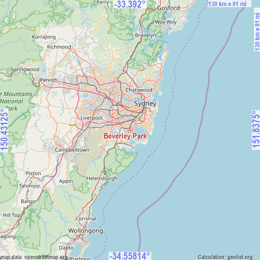
Beverley Park GPS coordinates[2]
33° 58' 37.452" South, 151° 8' 3.732" East
| Map corner | latitude | longitude |
|---|---|---|
| Upper-left | -33.392°, | 150.43125° |
| Center: | -33.97707°, | 151.13437° |
| Lower-right: | -34.55814°, | 151.8375° |
| Map W x H: | 129.7×129.7 km | = 80.6×80.6mi |
| max Lat: | -10.58257° ⇑58.4% North |
| Beverley Park: | -33.97707° |
| min Lat: | ⇓41.6% South -43.31423° |
| min Long | Beverley Park | max Long |
| 113.53327° | 151.13437° | 153.61246° |
| W 71.2%⇐ | ⇒28.8% E |
Elevation
Elevation of Beverley Park is 9 m = 30 ft, and this is 113 m = 371 ft below average elevation for this country.
| Max E: |
1715 m = 5627 ft | 90.1% |
| Avg. | 122 m = 400 ft | |
| Beverley Park | 9 m = 30 ft | |
Min E: |
-2 m = -7 ft | 9.9% |
See also: Australia elevation on elevation.city.
Geographical zone
Beverley Park is located in South temperate zone (between Tropic of Capricorn and the Antarctic Circle). Distance of this Southern Tropic circle is 1172 km =728.2 mi to North.| Distance of | km | miles | from Beverley Park |
|---|---|---|---|
| Equator | 3777.9 | 2347.5 | to North |
| Tropic Capricorn | 1172 | 728.2 | to North |
| Antarctic Circle | 3623.3 | 2251.4 | to South |
| South Pole | 6229.2 | 3870.6 | to South |


Nearby cities:
15 places around Beverley Park: (largest is in red/bold)
• Allawah
1.9 km =1.2 mi,  285°
285°
• Blakehurst
2.9 km =1.8 mi,  235°
235°
• Brighton-Le-Sands
2.4 km =1.5 mi,  39°
39°
• Carlton
1.4 km =0.9 mi,  299°
299°
• Carss Park
1.9 km =1.2 mi, 235°
• Dolls Point
2.1 km =1.3 mi,  152°
152°
• Kogarah
1 km =0.6 mi,  6°
6°
• Kogarah Bay
1.2 km =0.7 mi,  257°
257°
• Monterey
1.4 km =0.9 mi,  68°
68°
• Ramsgate
0.8 km =0.5 mi,  137°
137°
• Ramsgate Beach
1.4 km =0.9 mi,  129°
129°
• Rockdale
3 km =1.9 mi,  358°
358°
• Sandringham
2 km =1.2 mi,  167°
167°
• Sans Souci
1.4 km =0.9 mi,  183°
183°
• South Hurstville
2.7 km =1.7 mi,  268°
268°
Sources, notices
• [Note1] Compared only with cities in Australia existing in our database
• [Src1] Map data: © OpenStreetMap contributors (CC-BY-SA)
• [Src2] Other city data from geonames.org with taken over terms of usage.
• [Src3] Geographical zone / Annual Mean Temperature by Robert A. Rohde @ Wikipedia
