Padstow geodata
Padstow (New South Wales) is a section of populated place; located in Australia in Australia/Sydney (GMT+10) time zone. With population of 13,226 people, there are 346 cities with bigger population in this country. Compared to other cities in Australia, 58% of cities are located further ↑North; 68.1% of cities are located further ←West and 69.8% of cities have higher elevation than Padstow. Note1


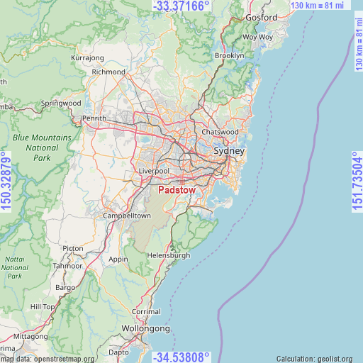
Padstow GPS coordinates[2]
33° 57' 24.732" South, 151° 1' 54.876" East
| Map corner | latitude | longitude |
|---|---|---|
| Upper-left | -33.37166°, | 150.32879° |
| Center: | -33.95687°, | 151.03191° |
| Lower-right: | -34.53808°, | 151.73504° |
| Map W x H: | 129.7×129.7 km | = 80.6×80.6mi |
| max Lat: | -10.58257° ⇑58% North |
| Padstow: | -33.95687° |
| min Lat: | ⇓42% South -43.31423° |
| min Long | Padstow | max Long |
| 113.53327° | 151.03191° | 153.61246° |
| W 68.1%⇐ | ⇒31.9% E |
Elevation
Elevation of Padstow is 23 m = 75 ft, and this is 99 m = 325 ft below average elevation for this country.
| Max E: |
1715 m = 5627 ft | 69.8% |
| Avg. | 122 m = 400 ft | |
| Padstow | 23 m = 75 ft | |
Min E: |
-2 m = -7 ft | 30.2% |
See also: Australia elevation on elevation.city.
Geographical zone
Padstow is located in South temperate zone (between Tropic of Capricorn and the Antarctic Circle). Distance of this Southern Tropic circle is 1169.7 km =726.8 mi to North.| Distance of | km | miles | from Padstow |
|---|---|---|---|
| Equator | 3775.7 | 2346.1 | to North |
| Tropic Capricorn | 1169.7 | 726.8 | to North |
| Antarctic Circle | 3625.5 | 2252.8 | to South |
| South Pole | 6231.4 | 3872 | to South |


Nearby cities:
15 places around Padstow: (largest is in red/bold)
• Alfords Point
3.5 km =2.2 mi,  190°
190°
• Condell Park
4.1 km =2.5 mi,  331°
331°
• East Hills
4.1 km =2.5 mi,  263°
263°
• Lugarno
3 km =1.9 mi,  162°
162°
• Mortdale
4 km =2.5 mi,  109°
109°
• Narwee
3.6 km =2.2 mi,  71°
71°
• Padstow Heights
1.4 km =0.9 mi,  147°
147°
• Panania
3.2 km =2 mi,  276°
276°
• Peakhurst
1.9 km =1.2 mi, 110°
• Peakhurst Heights
3.2 km =2 mi,  136°
136°
• Picnic Point
4.2 km =2.6 mi,  230°
230°
• Punchbowl
3.6 km =2.2 mi,  29°
29°
• Revesby
1.6 km =1 mi,  298°
298°
• Revesby Heights
1.7 km =1.1 mi, 227°
• Riverwood
2 km =1.2 mi,  56°
56°
Sources, notices
• [Note1] Compared only with cities in Australia existing in our database
• [Src1] Map data: © OpenStreetMap contributors (CC-BY-SA)
• [Src2] Other city data from geonames.org with taken over terms of usage.
• [Src3] Geographical zone / Annual Mean Temperature by Robert A. Rohde @ Wikipedia
