Riverwood geodata
Riverwood (New South Wales) is a section of populated place; located in Australia in Australia/Sydney (GMT+10) time zone. With population of 12,059 people, there are 406 cities with bigger population in this country. Compared to other cities in Australia, 57.7% of cities are located further ↑North; 68.6% of cities are located further ←West and 69.8% of cities have higher elevation than Riverwood. Note1


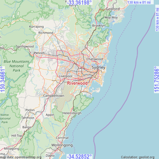
Riverwood GPS coordinates[2]
33° 56' 50.1" South, 151° 2' 59.028" East
| Map corner | latitude | longitude |
|---|---|---|
| Upper-left | -33.36198°, | 150.34661° |
| Center: | -33.94725°, | 151.04973° |
| Lower-right: | -34.52852°, | 151.75286° |
| Map W x H: | 129.7×129.7 km | = 80.6×80.6mi |
| max Lat: | -10.58257° ⇑57.7% North |
| Riverwood: | -33.94725° |
| min Lat: | ⇓42.3% South -43.31423° |
| min Long | Riverwood | max Long |
| 113.53327° | 151.04973° | 153.61246° |
| W 68.6%⇐ | ⇒31.4% E |
Elevation
Elevation of Riverwood is 23 m = 75 ft, and this is 99 m = 325 ft below average elevation for this country.
| Max E: |
1715 m = 5627 ft | 69.8% |
| Avg. | 122 m = 400 ft | |
| Riverwood | 23 m = 75 ft | |
Min E: |
-2 m = -7 ft | 30.2% |
See also: Australia elevation on elevation.city.
Geographical zone
Riverwood is located in South temperate zone (between Tropic of Capricorn and the Antarctic Circle). Distance of this Southern Tropic circle is 1168.7 km =726.2 mi to North.| Distance of | km | miles | from Riverwood |
|---|---|---|---|
| Equator | 3774.6 | 2345.4 | to North |
| Tropic Capricorn | 1168.7 | 726.2 | to North |
| Antarctic Circle | 3626.6 | 2253.5 | to South |
| South Pole | 6232.5 | 3872.7 | to South |


Nearby cities:
15 places around Riverwood: (largest is in red/bold)
• Bankstown
3.7 km =2.3 mi,  336°
336°
• Beverly Hills
2.8 km =1.7 mi,  91°
91°
• Mortdale
3.2 km =2 mi,  139°
139°
• Mount Lewis
3.3 km =2.1 mi,  357°
357°
• Narwee
1.8 km =1.1 mi, 87°
• Padstow
2 km =1.2 mi,  236°
236°
• Padstow Heights
2.4 km =1.5 mi,  202°
202°
• Peakhurst
1.7 km =1.1 mi,  174°
174°
• Peakhurst Heights
3.4 km =2.1 mi, 170°
• Penshurst
3.8 km =2.4 mi,  124°
124°
• Punchbowl
2 km =1.2 mi,  3°
3°
• Revesby
3.1 km =1.9 mi,  264°
264°
• Revesby Heights
3.6 km =2.2 mi,  232°
232°
• Roselands
2.7 km =1.7 mi,  54°
54°
• Wiley Park
3 km =1.9 mi,  32°
32°
Sources, notices
• [Note1] Compared only with cities in Australia existing in our database
• [Src1] Map data: © OpenStreetMap contributors (CC-BY-SA)
• [Src2] Other city data from geonames.org with taken over terms of usage.
• [Src3] Geographical zone / Annual Mean Temperature by Robert A. Rohde @ Wikipedia
