Burswood geodata
Burswood (Western Australia) is a populated place; located in Australia in Australia/Perth (GMT+8) time zone. With population of 2,780 people, there are 2389 cities with bigger population in this country. Compared to other cities in Australia, 65.6% of cities are located further ↓South; 93.8% of cities are located further →East and 79% of cities have higher elevation than Burswood. Note1


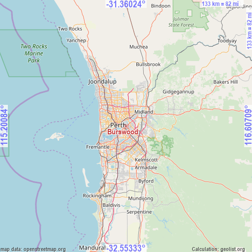
Burswood GPS coordinates[2]
31° 57' 31.392" South, 115° 54' 14.256" East
| Map corner | latitude | longitude |
|---|---|---|
| Upper-left | -31.36024°, | 115.20084° |
| Center: | -31.95872°, | 115.90396° |
| Lower-right: | -32.55333°, | 116.60709° |
| Map W x H: | 132.7×132.7 km | = 82.5×82.5mi |
| max Lat: | -10.58257° ⇑34.4% North |
| Burswood: | -31.95872° |
| min Lat: | ⇓65.6% South -43.31423° |
| min Long | Burswood | max Long |
| 113.53327° | 115.90396° | 153.61246° |
| W 6.2%⇐ | ⇒93.8% E |
Elevation
Elevation of Burswood is 16 m = 52 ft, and this is 106 m = 348 ft below average elevation for this country.
| Max E: |
1715 m = 5627 ft | 79% |
| Avg. | 122 m = 400 ft | |
| Burswood | 16 m = 52 ft | |
Min E: |
-2 m = -7 ft | 21% |
See also: Australia elevation on elevation.city.
Geographical zone
Burswood is located in South temperate zone (between Tropic of Capricorn and the Antarctic Circle). Distance of this Southern Tropic circle is 947.6 km =588.8 mi to North.| Distance of | km | miles | from Burswood |
|---|---|---|---|
| Equator | 3553.5 | 2208 | to North |
| Tropic Capricorn | 947.6 | 588.8 | to North |
| Antarctic Circle | 3847.7 | 2390.8 | to South |
| South Pole | 6453.6 | 4010.1 | to South |


Nearby cities:
15 places around Burswood: (largest is in red/bold)
• Ascot
2.9 km =1.8 mi,  37°
37°
• Belmont
2.6 km =1.6 mi,  50°
50°
• Carlisle
2.7 km =1.7 mi,  149°
149°
• Cloverdale
3.8 km =2.4 mi,  96°
96°
• East Perth
3.1 km =1.9 mi,  270°
270°
• East Victoria Park
3.4 km =2.1 mi,  180°
180°
• Highgate
3.8 km =2.4 mi,  303°
303°
• Lathlain
1 km =0.6 mi,  167°
167°
• Maylands
3.2 km =2 mi,  344°
344°
• Mount Lawley
4.1 km =2.5 mi,  311°
311°
• Northbridge
4.4 km =2.7 mi,  285°
285°
• Perth
4.1 km =2.5 mi,  280°
280°
• Rivervale
0.9 km =0.6 mi,  67°
67°
• South Perth
4.5 km =2.8 mi,  232°
232°
• Victoria Park
1.9 km =1.2 mi, 176°
Sources, notices
• [Note1] Compared only with cities in Australia existing in our database
• [Src1] Map data: © OpenStreetMap contributors (CC-BY-SA)
• [Src2] Other city data from geonames.org with taken over terms of usage.
• [Src3] Geographical zone / Annual Mean Temperature by Robert A. Rohde @ Wikipedia
