Maylands geodata
Maylands (Western Australia) is a populated place; located in Australia in Australia/Perth (GMT+8) time zone. With population of 12,101 people, there are 399 cities with bigger population in this country. Compared to other cities in Australia, 66.1% of cities are located further ↓South; 93.9% of cities are located further →East and 72.3% of cities have higher elevation than Maylands. Note1


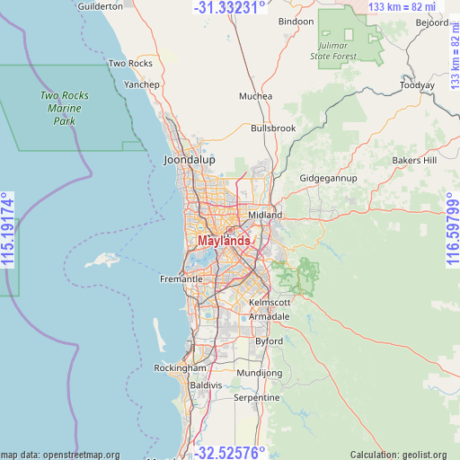
Maylands GPS coordinates[2]
31° 55' 51.492" South, 115° 53' 41.496" East
| Map corner | latitude | longitude |
|---|---|---|
| Upper-left | -31.33231°, | 115.19174° |
| Center: | -31.93097°, | 115.89486° |
| Lower-right: | -32.52576°, | 116.59799° |
| Map W x H: | 132.7×132.7 km | = 82.5×82.5mi |
| max Lat: | -10.58257° ⇑33.9% North |
| Maylands: | -31.93097° |
| min Lat: | ⇓66.1% South -43.31423° |
| min Long | Maylands | max Long |
| 113.53327° | 115.89486° | 153.61246° |
| W 6.1%⇐ | ⇒93.9% E |
Elevation
Elevation of Maylands is 21 m = 69 ft, and this is 101 m = 331 ft below average elevation for this country.
| Max E: |
1715 m = 5627 ft | 72.3% |
| Avg. | 122 m = 400 ft | |
| Maylands | 21 m = 69 ft | |
Min E: |
-2 m = -7 ft | 27.7% |
See also: Australia elevation on elevation.city.
Geographical zone
Maylands is located in South temperate zone (between Tropic of Capricorn and the Antarctic Circle). Distance of this Southern Tropic circle is 944.5 km =586.9 mi to North.| Distance of | km | miles | from Maylands |
|---|---|---|---|
| Equator | 3550.4 | 2206.1 | to North |
| Tropic Capricorn | 944.5 | 586.9 | to North |
| Antarctic Circle | 3850.8 | 2392.8 | to South |
| South Pole | 6456.7 | 4012 | to South |


Nearby cities:
15 places around Maylands: (largest is in red/bold)
• Ascot
2.7 km =1.7 mi,  107°
107°
• Bayswater
2.7 km =1.7 mi,  54°
54°
• Bedford
2.2 km =1.4 mi,  346°
346°
• Belmont
3.2 km =2 mi,  115°
115°
• Burswood
3.2 km =2 mi,  164°
164°
• East Perth
3.8 km =2.4 mi,  216°
216°
• Embleton
3.3 km =2.1 mi,  23°
23°
• Highgate
2.5 km =1.6 mi,  247°
247°
• Inglewood
2.1 km =1.3 mi,  318°
318°
• Menora
3.4 km =2.1 mi,  293°
293°
• Mount Lawley
2.2 km =1.4 mi,  260°
260°
• North Perth
4 km =2.5 mi,  275°
275°
• Northbridge
3.9 km =2.4 mi,  241°
241°
• Perth
3.9 km =2.4 mi,  233°
233°
• Rivervale
3.2 km =2 mi,  147°
147°
Sources, notices
• [Note1] Compared only with cities in Australia existing in our database
• [Src1] Map data: © OpenStreetMap contributors (CC-BY-SA)
• [Src2] Other city data from geonames.org with taken over terms of usage.
• [Src3] Geographical zone / Annual Mean Temperature by Robert A. Rohde @ Wikipedia
