Milton geodata
Milton (Queensland) is a section of populated place; located in Australia in Australia/Brisbane (GMT+10) time zone. With population of 2,300 people, there are 2694 cities with bigger population in this country. Compared to other cities in Australia, 82.5% of cities are located further ↓South; 91.3% of cities are located further ←West and 81.9% of cities have higher elevation than Milton. Note1


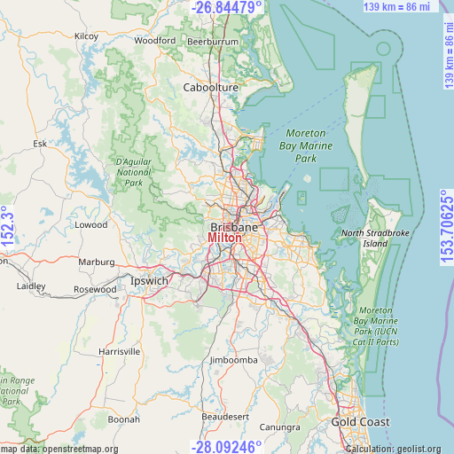
Milton GPS coordinates[2]
27° 28' 13.404" South, 153° 0' 11.232" East
| Map corner | latitude | longitude |
|---|---|---|
| Upper-left | -26.84479°, | 152.3° |
| Center: | -27.47039°, | 153.00312° |
| Lower-right: | -28.09246°, | 153.70625° |
| Map W x H: | 138.7×138.7 km | = 86.2×86.2mi |
| max Lat: | -10.58257° ⇑17.5% North |
| Milton: | -27.47039° |
| min Lat: | ⇓82.5% South -43.31423° |
| min Long | Milton | max Long |
| 113.53327° | 153.00312° | 153.61246° |
| W 91.3%⇐ | ⇒8.7% E |
Elevation
Elevation of Milton is 14 m = 46 ft, and this is 108 m = 354 ft below average elevation for this country.
| Max E: |
1715 m = 5627 ft | 81.9% |
| Avg. | 122 m = 400 ft | |
| Milton | 14 m = 46 ft | |
Min E: |
-2 m = -7 ft | 18.1% |
See also: Australia elevation on elevation.city.
Geographical zone
Milton is located in South temperate zone (between Tropic of Capricorn and the Antarctic Circle). Distance of this Southern Tropic circle is 448.5 km =278.7 mi to North.| Distance of | km | miles | from Milton |
|---|---|---|---|
| Equator | 3054.4 | 1897.9 | to North |
| Tropic Capricorn | 448.5 | 278.7 | to North |
| Antarctic Circle | 4346.8 | 2701 | to South |
| South Pole | 6952.6 | 4320.1 | to South |


Nearby cities:
15 places around Milton: (largest is in red/bold)
• Ashgrove
3 km =1.9 mi,  338°
338°
• Auchenflower
1.2 km =0.7 mi,  247°
247°
• Bardon
2.6 km =1.6 mi,  293°
293°
• Brisbane
2.5 km =1.6 mi,  83°
83°
• Fortitude Valley
3.2 km =2 mi,  62°
62°
• Herston
3.3 km =2.1 mi,  27°
27°
• Highgate Hill
2.6 km =1.6 mi,  143°
143°
• Kelvin Grove
2.7 km =1.7 mi,  22°
22°
• Paddington
1.5 km =0.9 mi,  327°
327°
• Petrie Terrace
1.3 km =0.8 mi,  50°
50°
• Red Hill
2 km =1.2 mi,  357°
357°
• South Brisbane
2 km =1.2 mi,  122°
122°
• Spring Hill
2.2 km =1.4 mi, 63°
• Toowong
2.4 km =1.5 mi,  233°
233°
• West End
1.2 km =0.7 mi,  146°
146°
Sources, notices
• [Note1] Compared only with cities in Australia existing in our database
• [Src1] Map data: © OpenStreetMap contributors (CC-BY-SA)
• [Src2] Other city data from geonames.org with taken over terms of usage.
• [Src3] Geographical zone / Annual Mean Temperature by Robert A. Rohde @ Wikipedia
