Auchenflower geodata
Auchenflower (Queensland) is a section of populated place; located in Australia in Australia/Brisbane (GMT+10) time zone. With population of 6,196 people, there are 1151 cities with bigger population in this country. Compared to other cities in Australia, 82.4% of cities are located further ↓South; 90.9% of cities are located further ←West and 63.7% of cities have higher elevation than Auchenflower. Note1


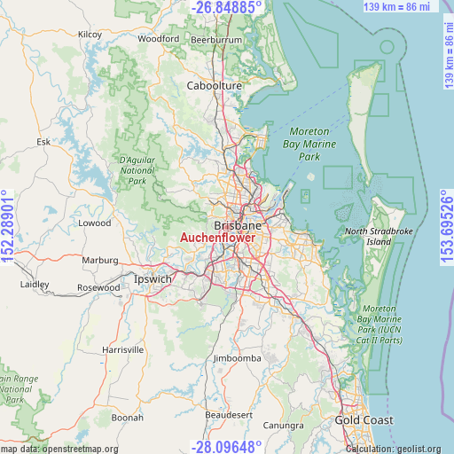
Auchenflower GPS coordinates[2]
27° 28' 27.948" South, 152° 59' 31.668" East
| Map corner | latitude | longitude |
|---|---|---|
| Upper-left | -26.84885°, | 152.28901° |
| Center: | -27.47443°, | 152.99213° |
| Lower-right: | -28.09648°, | 153.69526° |
| Map W x H: | 138.7×138.7 km | = 86.2×86.2mi |
| max Lat: | -10.58257° ⇑17.6% North |
| Auchenflower: | -27.47443° |
| min Lat: | ⇓82.4% South -43.31423° |
| min Long | Auchenflower | max Long |
| 113.53327° | 152.99213° | 153.61246° |
| W 90.9%⇐ | ⇒9.1% E |
Elevation
Elevation of Auchenflower is 28 m = 92 ft, and this is 94 m = 308 ft below average elevation for this country.
| Max E: |
1715 m = 5627 ft | 63.7% |
| Avg. | 122 m = 400 ft | |
| Auchenflower | 28 m = 92 ft | |
Min E: |
-2 m = -7 ft | 36.3% |
See also: Australia elevation on elevation.city.
Geographical zone
Auchenflower is located in South temperate zone (between Tropic of Capricorn and the Antarctic Circle). Distance of this Southern Tropic circle is 449 km =279 mi to North.| Distance of | km | miles | from Auchenflower |
|---|---|---|---|
| Equator | 3054.9 | 1898.2 | to North |
| Tropic Capricorn | 449 | 279 | to North |
| Antarctic Circle | 4346.3 | 2700.7 | to South |
| South Pole | 6952.2 | 4319.9 | to South |


Nearby cities:
15 places around Auchenflower: (largest is in red/bold)
• Ashgrove
3.2 km =2 mi,  359°
359°
• Bardon
2 km =1.2 mi,  319°
319°
• Brisbane
3.6 km =2.2 mi,  78°
78°
• Highgate Hill
3.1 km =1.9 mi,  121°
121°
• Indooroopilly
3.6 km =2.2 mi,  207°
207°
• Kelvin Grove
3.6 km =2.2 mi,  35°
35°
• Milton
1.2 km =0.7 mi,  67°
67°
• Paddington
1.7 km =1.1 mi,  9°
9°
• Petrie Terrace
2.4 km =1.5 mi,  58°
58°
• Red Hill
2.6 km =1.6 mi,  21°
21°
• South Brisbane
2.9 km =1.8 mi,  103°
103°
• Spring Hill
3.4 km =2.1 mi, 64°
• Taringa
2.2 km =1.4 mi,  216°
216°
• Toowong
1.3 km =0.8 mi, 221°
• West End
1.8 km =1.1 mi,  107°
107°
Sources, notices
• [Note1] Compared only with cities in Australia existing in our database
• [Src1] Map data: © OpenStreetMap contributors (CC-BY-SA)
• [Src2] Other city data from geonames.org with taken over terms of usage.
• [Src3] Geographical zone / Annual Mean Temperature by Robert A. Rohde @ Wikipedia
