Woodgate geodata
Woodgate (Queensland) is a populated place; located in Australia in Australia/Brisbane (GMT+10) time zone. With population of 1,454 people, there are 3318 cities with bigger population in this country. Compared to other cities in Australia, 89.6% of cities are located further ↓South; 84.9% of cities are located further ←West and 88.3% of cities have higher elevation than Woodgate. Note1


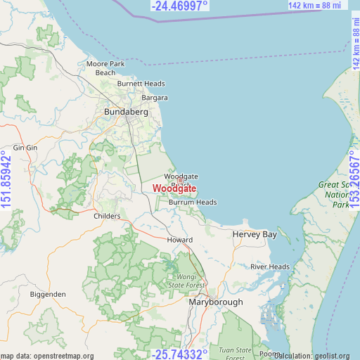
Woodgate GPS coordinates[2]
25° 6' 29.88" South, 152° 33' 45.144" East
| Map corner | latitude | longitude |
|---|---|---|
| Upper-left | -24.46997°, | 151.85942° |
| Center: | -25.1083°, | 152.56254° |
| Lower-right: | -25.74332°, | 153.26567° |
| Map W x H: | 141.6×141.6 km | = 88×88mi |
| max Lat: | -10.58257° ⇑10.4% North |
| Woodgate: | -25.1083° |
| min Lat: | ⇓89.6% South -43.31423° |
| min Long | Woodgate | max Long |
| 113.53327° | 152.56254° | 153.61246° |
| W 84.9%⇐ | ⇒15.1% E |
Elevation
Elevation of Woodgate is 10 m = 33 ft, and this is 112 m = 367 ft below average elevation for this country.
| Max E: |
1715 m = 5627 ft | 88.3% |
| Avg. | 122 m = 400 ft | |
| Woodgate | 10 m = 33 ft | |
Min E: |
-2 m = -7 ft | 11.7% |
See also: Australia elevation on elevation.city.
Geographical zone
Woodgate is located in South temperate zone (between Tropic of Capricorn and the Antarctic Circle). Distance of this Southern Tropic circle is 185.9 km =115.5 mi to North.| Distance of | km | miles | from Woodgate |
|---|---|---|---|
| Equator | 2791.8 | 1734.7 | to North |
| Tropic Capricorn | 185.9 | 115.5 | to North |
| Antarctic Circle | 4609.4 | 2864.1 | to South |
| South Pole | 7215.3 | 4483.4 | to South |


Nearby cities:
15 places around Woodgate: (largest is in red/bold)
• Burrum Heads
9.9 km =6.2 mi,  149°
149°
• Coral Cove
26.3 km =16.3 mi,  342°
342°
• Craignish
25.3 km =15.7 mi,  139°
139°
• Dundowran
29.7 km =18.5 mi,  134°
134°
• Dundowran Beach
26.9 km =16.7 mi, 131°
• Elliott Heads
22.6 km =14 mi, 341°
• Hervey Bay
28.8 km =17.9 mi, 133°
• Howard
23.5 km =14.6 mi,  180°
180°
• Innes Park
28 km =17.4 mi, 342°
• Pacific Haven
17.5 km =10.9 mi, 183°
• Redridge
21.4 km =13.3 mi,  251°
251°
• Takura
26.9 km =16.7 mi, 150°
• Toogoom
20.9 km =13 mi, 142°
• Torbanlea
26.5 km =16.5 mi,  173°
173°
• Woongarra
27.3 km =17 mi,  328°
328°
Sources, notices
• [Note1] Compared only with cities in Australia existing in our database
• [Src1] Map data: © OpenStreetMap contributors (CC-BY-SA)
• [Src2] Other city data from geonames.org with taken over terms of usage.
• [Src3] Geographical zone / Annual Mean Temperature by Robert A. Rohde @ Wikipedia
