Murarrie geodata
Murarrie (Queensland) is a section of populated place; located in Australia in Australia/Brisbane (GMT+10) time zone. With population of 4,192 people, there are 1719 cities with bigger population in this country. Compared to other cities in Australia, 82.7% of cities are located further ↓South; 94.7% of cities are located further ←West and 58.4% of cities have higher elevation than Murarrie. Note1


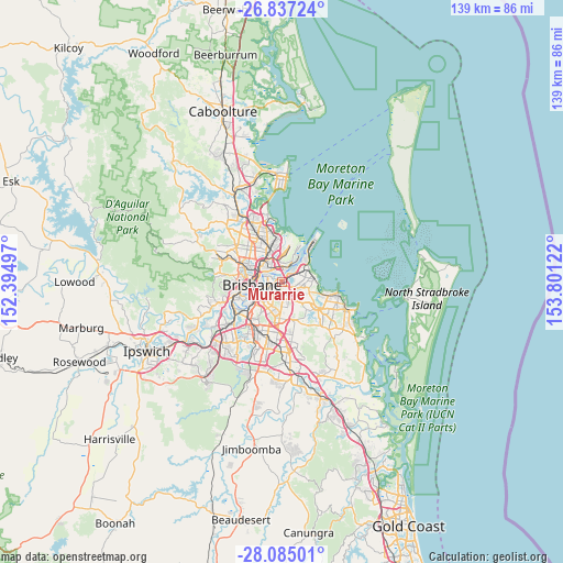
Murarrie GPS coordinates[2]
27° 27' 46.404" South, 153° 5' 53.124" East
| Map corner | latitude | longitude |
|---|---|---|
| Upper-left | -26.83724°, | 152.39497° |
| Center: | -27.46289°, | 153.09809° |
| Lower-right: | -28.08501°, | 153.80122° |
| Map W x H: | 138.7×138.7 km | = 86.2×86.2mi |
| max Lat: | -10.58257° ⇑17.3% North |
| Murarrie: | -27.46289° |
| min Lat: | ⇓82.7% South -43.31423° |
| min Long | Murarrie | max Long |
| 113.53327° | 153.09809° | 153.61246° |
| W 94.7%⇐ | ⇒5.3% E |
Elevation
Elevation of Murarrie is 34 m = 112 ft, and this is 88 m = 289 ft below average elevation for this country.
| Max E: |
1715 m = 5627 ft | 58.4% |
| Avg. | 122 m = 400 ft | |
| Murarrie | 34 m = 112 ft | |
Min E: |
-2 m = -7 ft | 41.6% |
See also: Australia elevation on elevation.city.
Geographical zone
Murarrie is located in South temperate zone (between Tropic of Capricorn and the Antarctic Circle). Distance of this Southern Tropic circle is 447.7 km =278.2 mi to North.| Distance of | km | miles | from Murarrie |
|---|---|---|---|
| Equator | 3053.6 | 1897.4 | to North |
| Tropic Capricorn | 447.7 | 278.2 | to North |
| Antarctic Circle | 4347.6 | 2701.5 | to South |
| South Pole | 6953.5 | 4320.7 | to South |


Nearby cities:
15 places around Murarrie: (largest is in red/bold)
• Balmoral
3.3 km =2.1 mi,  288°
288°
• Bulimba
4.2 km =2.6 mi, 289°
• Camp Hill
4 km =2.5 mi,  212°
212°
• Cannon Hill
1.1 km =0.7 mi,  197°
197°
• Carina Heights
5 km =3.1 mi,  187°
187°
• Carindale
4.8 km =3 mi,  174°
174°
• Hamilton
4.4 km =2.7 mi,  307°
307°
• Hawthorne
4 km =2.5 mi,  263°
263°
• Hemmant
3.7 km =2.3 mi,  63°
63°
• Morningside
2.3 km =1.4 mi,  273°
273°
• New Farm
4.9 km =3 mi, 263°
• Norman Park
3.9 km =2.4 mi,  242°
242°
• Seven Hills
3.2 km =2 mi,  225°
225°
• Teneriffe
5.1 km =3.2 mi,  278°
278°
• Tingalpa
3.1 km =1.9 mi,  112°
112°
Sources, notices
• [Note1] Compared only with cities in Australia existing in our database
• [Src1] Map data: © OpenStreetMap contributors (CC-BY-SA)
• [Src2] Other city data from geonames.org with taken over terms of usage.
• [Src3] Geographical zone / Annual Mean Temperature by Robert A. Rohde @ Wikipedia
