Glossodia geodata
Glossodia (New South Wales) is a section of populated place; located in Australia in Australia/Sydney (GMT+11) time zone. With population of 2,807 people, there are 2374 cities with bigger population in this country. Compared to other cities in Australia, 53.1% of cities are located further ↓South; 61.9% of cities are located further ←West and 64% of cities have lower elevation than Glossodia. Note1


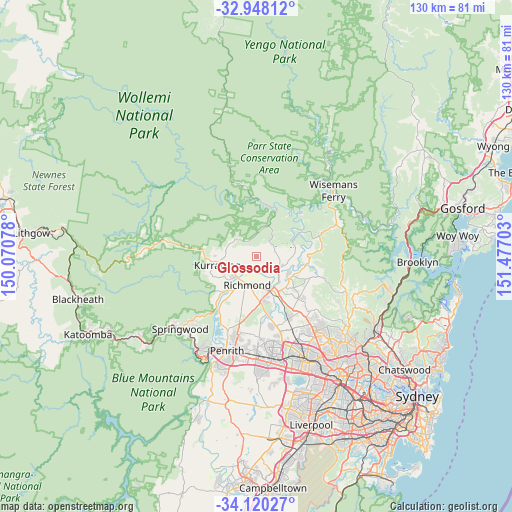
Glossodia GPS coordinates[2]
33° 32' 10.248" South, 150° 46' 26.04" East
| Map corner | latitude | longitude |
|---|---|---|
| Upper-left | -32.94812°, | 150.07078° |
| Center: | -33.53618°, | 150.7739° |
| Lower-right: | -34.12027°, | 151.47703° |
| Map W x H: | 130.3×130.3 km | = 81×81mi |
| max Lat: | -10.58257° ⇑46.9% North |
| Glossodia: | -33.53618° |
| min Lat: | ⇓53.1% South -43.31423° |
| min Long | Glossodia | max Long |
| 113.53327° | 150.7739° | 153.61246° |
| W 61.9%⇐ | ⇒38.1% E |
Elevation
Elevation of Glossodia is 76 m = 249 ft, and this is 46 m = 151 ft below average elevation for this country.
| Max E: |
1715 m = 5627 ft | 36% |
| Avg. | 122 m = 400 ft | |
| Glossodia | 76 m = 249 ft | |
Min E: |
-2 m = -7 ft | 64% |
See also: Australia elevation on elevation.city.
Geographical zone
Glossodia is located in South temperate zone (between Tropic of Capricorn and the Antarctic Circle). Distance of this Southern Tropic circle is 1123 km =697.8 mi to North.| Distance of | km | miles | from Glossodia |
|---|---|---|---|
| Equator | 3728.9 | 2317 | to North |
| Tropic Capricorn | 1123 | 697.8 | to North |
| Antarctic Circle | 3672.3 | 2281.9 | to South |
| South Pole | 6278.2 | 3901.1 | to South |


Nearby cities:
15 places around Glossodia: (largest is in red/bold)
• Agnes Banks
9.7 km =6 mi,  213°
213°
• East Kurrajong
3.9 km =2.4 mi,  28°
28°
• Ebenezer
10.6 km =6.6 mi,  80°
80°
• Freemans Reach
3.1 km =1.9 mi,  140°
140°
• Grose Vale
10.6 km =6.6 mi,  240°
240°
• Grose Wold
10.8 km =6.7 mi,  230°
230°
• Hobartville
8.1 km =5 mi,  200°
200°
• Kurmond
7.6 km =4.7 mi,  255°
255°
• McGraths Hill
10.4 km =6.5 mi,  147°
147°
• North Richmond
7.1 km =4.4 mi, 225°
• Pitt Town
9.7 km =6 mi,  125°
125°
• Richmond
7.3 km =4.5 mi, 196°
• South Windsor
9.5 km =5.9 mi,  162°
162°
• Wilberforce
6.6 km =4.1 mi,  116°
116°
• Windsor
9.3 km =5.8 mi, 156°
Sources, notices
• [Note1] Compared only with cities in Australia existing in our database
• [Src1] Map data: © OpenStreetMap contributors (CC-BY-SA)
• [Src2] Other city data from geonames.org with taken over terms of usage.
• [Src3] Geographical zone / Annual Mean Temperature by Robert A. Rohde @ Wikipedia
