Ebenezer geodata
Ebenezer (New South Wales) is a section of populated place; located in Australia in Australia/Sydney (GMT+11) time zone. With population of 976 people, there are 3861 cities with bigger population in this country. Compared to other cities in Australia, 53.2% of cities are located further ↓South; 65% of cities are located further ←West and 64.8% of cities have higher elevation than Ebenezer. Note1


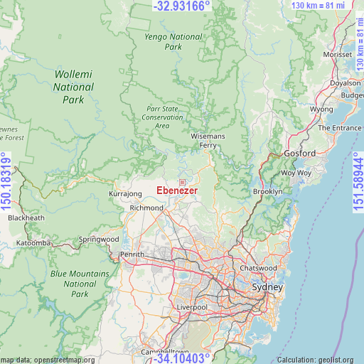
Ebenezer GPS coordinates[2]
33° 31' 11.388" South, 150° 53' 10.716" East
| Map corner | latitude | longitude |
|---|---|---|
| Upper-left | -32.93166°, | 150.18319° |
| Center: | -33.51983°, | 150.88631° |
| Lower-right: | -34.10403°, | 151.58944° |
| Map W x H: | 130.4×130.4 km | = 81×81mi |
| max Lat: | -10.58257° ⇑46.8% North |
| Ebenezer: | -33.51983° |
| min Lat: | ⇓53.2% South -43.31423° |
| min Long | Ebenezer | max Long |
| 113.53327° | 150.88631° | 153.61246° |
| W 65%⇐ | ⇒35% E |
Elevation
Elevation of Ebenezer is 27 m = 89 ft, and this is 95 m = 312 ft below average elevation for this country.
| Max E: |
1715 m = 5627 ft | 64.8% |
| Avg. | 122 m = 400 ft | |
| Ebenezer | 27 m = 89 ft | |
Min E: |
-2 m = -7 ft | 35.2% |
See also: Australia elevation on elevation.city.
Geographical zone
Ebenezer is located in South temperate zone (between Tropic of Capricorn and the Antarctic Circle). Distance of this Southern Tropic circle is 1121.1 km =696.6 mi to North.| Distance of | km | miles | from Ebenezer |
|---|---|---|---|
| Equator | 3727.1 | 2315.9 | to North |
| Tropic Capricorn | 1121.1 | 696.6 | to North |
| Antarctic Circle | 3674.1 | 2283 | to South |
| South Pole | 6280 | 3902.2 | to South |


Nearby cities:
15 places around Ebenezer: (largest is in red/bold)
• Cattai
3.9 km =2.4 mi,  137°
137°
• East Kurrajong
8.7 km =5.4 mi,  280°
280°
• Freemans Reach
9.4 km =5.8 mi,  243°
243°
• Glenorie
14.6 km =9.1 mi,  128°
128°
• Glossodia
10.6 km =6.6 mi,  260°
260°
• Lower Portland
7.8 km =4.8 mi,  357°
357°
• Maraylya
8.6 km =5.3 mi,  158°
158°
• Maroota
11 km =6.8 mi,  54°
54°
• McGraths Hill
11.7 km =7.3 mi,  204°
204°
• Oakville
10.7 km =6.6 mi,  183°
183°
• Pitt Town
7.9 km =4.9 mi, 198°
• South Maroota
6.8 km =4.2 mi,  74°
74°
• South Windsor
13.3 km =8.3 mi,  214°
214°
• Wilberforce
6.5 km =4 mi,  223°
223°
• Windsor
12.3 km =7.6 mi, 212°
Sources, notices
• [Note1] Compared only with cities in Australia existing in our database
• [Src1] Map data: © OpenStreetMap contributors (CC-BY-SA)
• [Src2] Other city data from geonames.org with taken over terms of usage.
• [Src3] Geographical zone / Annual Mean Temperature by Robert A. Rohde @ Wikipedia
