Grose Wold geodata
Grose Wold (New South Wales) is a populated place; located in Australia in Australia/Sydney (GMT+11) time zone. With population of 633 people, there are 4481 cities with bigger population in this country. Compared to other cities in Australia, 52.6% of cities are located further ↓South; 60.6% of cities are located further ←West and 51.1% of cities have lower elevation than Grose Wold. Note1


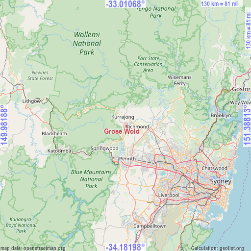
Grose Wold GPS coordinates[2]
33° 35' 53.952" South, 150° 41' 6" East
| Map corner | latitude | longitude |
|---|---|---|
| Upper-left | -33.01068°, | 149.98188° |
| Center: | -33.59832°, | 150.685° |
| Lower-right: | -34.18198°, | 151.38813° |
| Map W x H: | 130.2×130.2 km | = 80.9×80.9mi |
| max Lat: | -10.58257° ⇑47.4% North |
| Grose Wold: | -33.59832° |
| min Lat: | ⇓52.6% South -43.31423° |
| min Long | Grose Wold | max Long |
| 113.53327° | 150.685° | 153.61246° |
| W 60.6%⇐ | ⇒39.4% E |
Elevation
Elevation of Grose Wold is 47 m = 154 ft, and this is 75 m = 246 ft below average elevation for this country.
| Max E: |
1715 m = 5627 ft | 48.9% |
| Avg. | 122 m = 400 ft | |
| Grose Wold | 47 m = 154 ft | |
Min E: |
-2 m = -7 ft | 51.1% |
See also: Australia elevation on elevation.city.
Geographical zone
Grose Wold is located in South temperate zone (between Tropic of Capricorn and the Antarctic Circle). Distance of this Southern Tropic circle is 1129.9 km =702.1 mi to North.| Distance of | km | miles | from Grose Wold |
|---|---|---|---|
| Equator | 3735.8 | 2321.3 | to North |
| Tropic Capricorn | 1129.9 | 702.1 | to North |
| Antarctic Circle | 3665.4 | 2277.6 | to South |
| South Pole | 6271.3 | 3896.8 | to South |


Nearby cities:
15 places around Grose Wold: (largest is in red/bold)
• Agnes Banks
3.2 km =2 mi,  112°
112°
• Bowen Mountain
6.2 km =3.9 mi,  298°
298°
• Castlereagh
10.2 km =6.3 mi,  183°
183°
• Freemans Reach
11.2 km =7 mi,  66°
66°
• Glossodia
10.8 km =6.7 mi,  50°
50°
• Grose Vale
1.9 km =1.2 mi,  329°
329°
• Hobartville
5.4 km =3.4 mi,  97°
97°
• Kurmond
5.1 km =3.2 mi,  10°
10°
• Kurrajong Heights
9.4 km =5.8 mi, 326°
• Kurrajong Hills
7.9 km =4.9 mi,  336°
336°
• Londonderry
7.1 km =4.4 mi,  139°
139°
• North Richmond
3.7 km =2.3 mi,  59°
59°
• Richmond
6.2 km =3.9 mi,  91°
91°
• Winmalee
11.2 km =7 mi,  217°
217°
• Yarramundi
2.5 km =1.6 mi,  201°
201°
Sources, notices
• [Note1] Compared only with cities in Australia existing in our database
• [Src1] Map data: © OpenStreetMap contributors (CC-BY-SA)
• [Src2] Other city data from geonames.org with taken over terms of usage.
• [Src3] Geographical zone / Annual Mean Temperature by Robert A. Rohde @ Wikipedia
