Spalding geodata
Spalding (Western Australia) is a section of populated place; located in Australia in Australia/Perth (GMT+8) time zone. With population of 2,045 people, there are 2870 cities with bigger population in this country. Compared to other cities in Australia, 74% of cities are located further ↓South; 99.5% of cities are located further →East and 74.7% of cities have higher elevation than Spalding. Note1


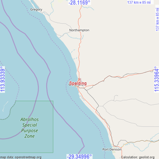
Spalding GPS coordinates[2]
28° 44' 6.9" South, 114° 38' 11.436" East
| Map corner | latitude | longitude |
|---|---|---|
| Upper-left | -28.1169°, | 113.93339° |
| Center: | -28.73525°, | 114.63651° |
| Lower-right: | -29.34996°, | 115.33964° |
| Map W x H: | 137.1×137.1 km | = 85.2×85.2mi |
| max Lat: | -10.58257° ⇑26% North |
| Spalding: | -28.73525° |
| min Lat: | ⇓74% South -43.31423° |
| min Long | Spalding | max Long |
| 113.53327° | 114.63651° | 153.61246° |
| W 0.5%⇐ | ⇒99.5% E |
Elevation
Elevation of Spalding is 19 m = 62 ft, and this is 103 m = 338 ft below average elevation for this country.
| Max E: |
1715 m = 5627 ft | 74.7% |
| Avg. | 122 m = 400 ft | |
| Spalding | 19 m = 62 ft | |
Min E: |
-2 m = -7 ft | 25.3% |
See also: Australia elevation on elevation.city.
Geographical zone
Spalding is located in South temperate zone (between Tropic of Capricorn and the Antarctic Circle). Distance of this Southern Tropic circle is 589.1 km =366 mi to North.| Distance of | km | miles | from Spalding |
|---|---|---|---|
| Equator | 3195.1 | 1985.3 | to North |
| Tropic Capricorn | 589.1 | 366 | to North |
| Antarctic Circle | 4206.1 | 2613.5 | to South |
| South Pole | 6812 | 4232.8 | to South |


Nearby cities:
15 places around Spalding: (largest is in red/bold)
• Beachlands
6.5 km =4 mi,  211°
211°
• Beresford
3 km =1.9 mi, 213°
• Bluff Point
1.4 km =0.9 mi,  259°
259°
• Geraldton
5.3 km =3.3 mi,  203°
203°
• Geraldton city centre
5.2 km =3.2 mi, 204°
• Glenfield
5 km =3.1 mi,  342°
342°
• Karloo
6.2 km =3.9 mi,  175°
175°
• Moresby
3.5 km =2.2 mi,  90°
90°
• Rangeway
5.7 km =3.5 mi,  185°
185°
• Strathalbyn
2 km =1.2 mi,  153°
153°
• Sunset Beach
2.2 km =1.4 mi,  323°
323°
• Utakarra
5.5 km =3.4 mi,  166°
166°
• Waggrakine
1.8 km =1.1 mi,  8°
8°
• Wonthella
3.5 km =2.2 mi, 184°
• Woorree
4.1 km =2.5 mi, 149°
Sources, notices
• [Note1] Compared only with cities in Australia existing in our database
• [Src1] Map data: © OpenStreetMap contributors (CC-BY-SA)
• [Src2] Other city data from geonames.org with taken over terms of usage.
• [Src3] Geographical zone / Annual Mean Temperature by Robert A. Rohde @ Wikipedia
