Prestons geodata
Prestons (New South Wales) is a section of populated place; located in Australia in Australia/Sydney (GMT+11) time zone. With population of 15,312 people, there are 264 cities with bigger population in this country. Compared to other cities in Australia, 57.5% of cities are located further ↑North; 64.7% of cities are located further ←West and 60% of cities have higher elevation than Prestons. Note1


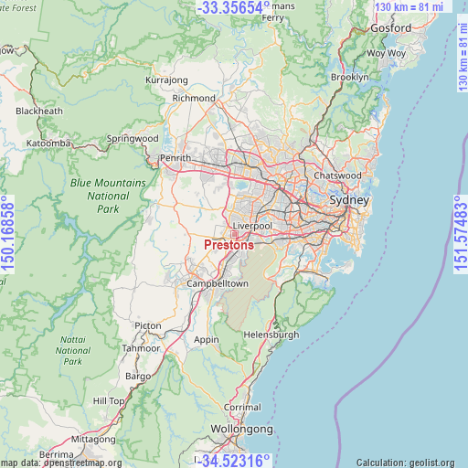
Prestons GPS coordinates[2]
33° 56' 30.66" South, 150° 52' 18.12" East
| Map corner | latitude | longitude |
|---|---|---|
| Upper-left | -33.35654°, | 150.16858° |
| Center: | -33.94185°, | 150.8717° |
| Lower-right: | -34.52316°, | 151.57483° |
| Map W x H: | 129.7×129.7 km | = 80.6×80.6mi |
| max Lat: | -10.58257° ⇑57.5% North |
| Prestons: | -33.94185° |
| min Lat: | ⇓42.5% South -43.31423° |
| min Long | Prestons | max Long |
| 113.53327° | 150.8717° | 153.61246° |
| W 64.7%⇐ | ⇒35.3% E |
Elevation
Elevation of Prestons is 32 m = 105 ft, and this is 90 m = 295 ft below average elevation for this country.
| Max E: |
1715 m = 5627 ft | 60% |
| Avg. | 122 m = 400 ft | |
| Prestons | 32 m = 105 ft | |
Min E: |
-2 m = -7 ft | 40% |
See also: Australia elevation on elevation.city.
Geographical zone
Prestons is located in South temperate zone (between Tropic of Capricorn and the Antarctic Circle). Distance of this Southern Tropic circle is 1168.1 km =725.8 mi to North.| Distance of | km | miles | from Prestons |
|---|---|---|---|
| Equator | 3774 | 2345.1 | to North |
| Tropic Capricorn | 1168.1 | 725.8 | to North |
| Antarctic Circle | 3627.2 | 2253.8 | to South |
| South Pole | 6233.1 | 3873.1 | to South |


Nearby cities:
15 places around Prestons: (largest is in red/bold)
• Ashcroft
3.9 km =2.4 mi,  42°
42°
• Busby
3.5 km =2.2 mi,  13°
13°
• Carnes Hill
2.1 km =1.3 mi,  280°
280°
• Cartwright
2.5 km =1.6 mi, 41°
• Casula
2.8 km =1.7 mi,  114°
114°
• Edmondson Park
1.9 km =1.2 mi,  209°
209°
• Glenfield
3.8 km =2.4 mi,  136°
136°
• Hinchinbrook
2.7 km =1.7 mi,  342°
342°
• Horningsea Park
2.4 km =1.5 mi,  265°
265°
• Hoxton Park
2 km =1.2 mi,  305°
305°
• Lurnea
2.4 km =1.5 mi,  72°
72°
• Middleton Grange
3.9 km =2.4 mi,  315°
315°
• Miller
2.6 km =1.6 mi,  27°
27°
• Sadleir
3.3 km =2.1 mi, 32°
• West Hoxton
3.7 km =2.3 mi, 283°
Sources, notices
• [Note1] Compared only with cities in Australia existing in our database
• [Src1] Map data: © OpenStreetMap contributors (CC-BY-SA)
• [Src2] Other city data from geonames.org with taken over terms of usage.
• [Src3] Geographical zone / Annual Mean Temperature by Robert A. Rohde @ Wikipedia
