Gnangara geodata
Gnangara (Western Australia) is a section of populated place; located in Australia in Australia/Perth (GMT+8) time zone. With population of 1,095 people, there are 3703 cities with bigger population in this country. Compared to other cities in Australia, 68.4% of cities are located further ↓South; 94.4% of cities are located further →East and 52% of cities have lower elevation than Gnangara. Note1


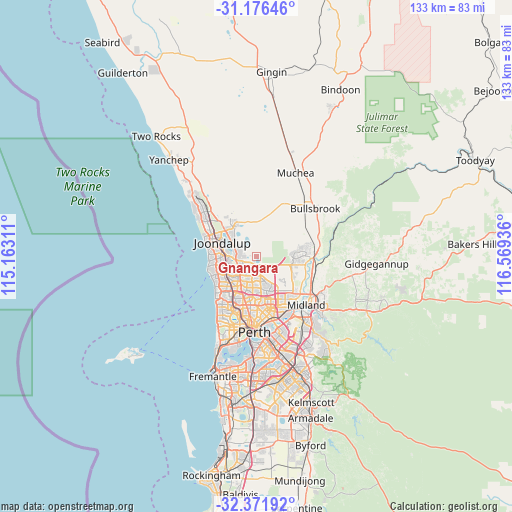
Gnangara GPS coordinates[2]
31° 46' 34.032" South, 115° 51' 58.428" East
| Map corner | latitude | longitude |
|---|---|---|
| Upper-left | -31.17646°, | 115.16311° |
| Center: | -31.77612°, | 115.86623° |
| Lower-right: | -32.37192°, | 116.56936° |
| Map W x H: | 132.9×132.9 km | = 82.6×82.6mi |
| max Lat: | -10.58257° ⇑31.6% North |
| Gnangara: | -31.77612° |
| min Lat: | ⇓68.4% South -43.31423° |
| min Long | Gnangara | max Long |
| 113.53327° | 115.86623° | 153.61246° |
| W 5.6%⇐ | ⇒94.4% E |
Elevation
Elevation of Gnangara is 48 m = 157 ft, and this is 74 m = 243 ft below average elevation for this country.
| Max E: |
1715 m = 5627 ft | 48% |
| Avg. | 122 m = 400 ft | |
| Gnangara | 48 m = 157 ft | |
Min E: |
-2 m = -7 ft | 52% |
See also: Australia elevation on elevation.city.
Geographical zone
Gnangara is located in South temperate zone (between Tropic of Capricorn and the Antarctic Circle). Distance of this Southern Tropic circle is 927.3 km =576.2 mi to North.| Distance of | km | miles | from Gnangara |
|---|---|---|---|
| Equator | 3533.2 | 2195.4 | to North |
| Tropic Capricorn | 927.3 | 576.2 | to North |
| Antarctic Circle | 3868 | 2403.5 | to South |
| South Pole | 6473.9 | 4022.7 | to South |


Nearby cities:
15 places around Gnangara: (largest is in red/bold)
• Alexander Heights
5.7 km =3.5 mi,  181°
181°
• Ballajura
7.7 km =4.8 mi,  158°
158°
• Darch
4.5 km =2.8 mi,  205°
205°
• Girrawheen
7.6 km =4.7 mi,  199°
199°
• Hocking
4.6 km =2.9 mi,  278°
278°
• Kingsley
7.3 km =4.5 mi,  238°
238°
• Koondoola
7.3 km =4.5 mi, 179°
• Landsdale
3.5 km =2.2 mi, 180°
• Madeley
5.3 km =3.3 mi,  222°
222°
• Marangaroo
6.2 km =3.9 mi, 204°
• Mariginiup
7.6 km =4.7 mi,  343°
343°
• Pearsall
4.6 km =2.9 mi,  262°
262°
• Sinagra
6.8 km =4.2 mi,  303°
303°
• Wanneroo
6.9 km =4.3 mi,  294°
294°
• Woodvale
6.7 km =4.2 mi, 257°
Sources, notices
• [Note1] Compared only with cities in Australia existing in our database
• [Src1] Map data: © OpenStreetMap contributors (CC-BY-SA)
• [Src2] Other city data from geonames.org with taken over terms of usage.
• [Src3] Geographical zone / Annual Mean Temperature by Robert A. Rohde @ Wikipedia
